
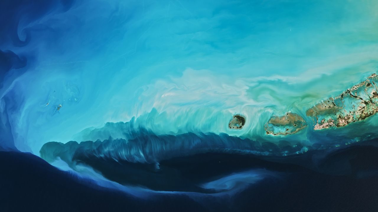
A pale blue plume appeared off the southwest coast of Florida in early February 2026 — and it was visible from space. NASA’s Terra satellite captured the striking image on February 3, 2026, revealing a swirling cloud of bright sediment stretching through the Gulf of Mexico near the Florida Keys.

The cause wasn’t an industrial spill or an underwater eruption. It was weather — specifically, an extreme blast of Arctic air pushed southward by the polar vortex that stirred up the seafloor and painted one of the most visually dramatic satellite images of the year.
The image is beautiful, but it tells a bigger story about how powerful cold weather events can physically reshape what we see from orbit — and how interconnected Earth’s atmosphere and oceans really are.
What NASA’s Satellite Actually Captured
The bright plume you see in the image isn’t algae, pollution, or warm-water discharge. It’s calcium-carbonate-rich mud — fine sediment that was stirred up from the shallow seafloor by the force of the cold air blast moving over the water.
The location is the Gulf of Mexico, specifically off the Florida Keys, centered around coordinates 24.5786632, -82.52266106. That stretch of the Gulf is notably shallow in places, which makes it especially vulnerable to sediment disturbance when strong winds and cold fronts push through.
When Arctic air surges over warm, shallow coastal waters, it doesn’t just drop the temperature. It generates strong surface winds that churn the water column, lifting fine sediment from the bottom and suspending it near the surface. From space, that suspended material scatters light in a way that gives it an almost luminous, pale blue glow — a striking contrast against the darker surrounding ocean.
The satellite that caught all of this was NASA’s Terra, one of the agency’s flagship Earth-observing platforms, which has been monitoring the planet’s surface, atmosphere, and oceans for decades.
The Polar Vortex’s Role in All of This
The polar vortex gets a lot of attention during winter cold snaps, and for good reason. When the vortex — a large area of low pressure and cold air surrounding the Earth’s poles — weakens or becomes disrupted, it can push frigid Arctic air much further south than usual.
That’s exactly what happened here. The polar vortex sent an extreme cold blast across the eastern United States, and the effects didn’t stop at the shoreline. The air mass continued over the Gulf of Mexico, and the energy it carried was enough to disturb the seafloor sediment in the shallow coastal waters near Florida.
It’s a reminder that what happens in the upper atmosphere can leave visible marks hundreds of miles away — and that Earth’s systems don’t operate in isolation. A disruption at the poles can show up as a glowing plume in a NASA satellite photo over Florida within days.
Key Facts About the Image and Event
| Detail | Information |
|---|---|
| Location | Gulf of Mexico, off the Florida Keys |
| Coordinates | 24.5786632, -82.52266106 |
| Date Captured | February 3, 2026 |
| Satellite | NASA’s Terra |
| What’s Visible | Bright plume of calcium-carbonate-rich mud |
| Cause | Arctic air blast driven by polar vortex disruption |
- The plume appears pale blue due to the way calcium carbonate particles scatter light near the water’s surface
- The shallow depth of the Gulf near the Florida Keys makes this area particularly prone to sediment disturbance
- NASA’s Terra satellite is one of the primary tools used to capture large-scale Earth surface events like this
- The Arctic air blast affected the broader eastern United States before extending over the Gulf
Why This Matters Beyond a Pretty Picture
Satellite images like this one aren’t just visually striking — they serve as real-time records of how Earth’s interconnected systems respond to extreme weather. Scientists use sediment plume data to track coastal erosion patterns, water clarity changes, and the impact of cold-weather events on shallow marine environments.
For the Florida Keys region specifically, sediment disturbances can affect coral reefs and seagrass beds that depend on clear, calm water. When large plumes of calcium carbonate mud get suspended in the water column, they can temporarily reduce light penetration — which matters enormously for photosynthetic marine organisms that live in those coastal ecosystems.
The event also underscores how extreme cold snaps — even ones that feel like a purely atmospheric story — have physical consequences that reach into the ocean. As polar vortex disruptions become a recurring feature of winter weather discussions, images like this one help illustrate that the effects are measurable, visible from space, and ecologically significant.
What Comes Next After an Event Like This
Sediment plumes like the one captured on February 3 are typically temporary. Once the wind energy subsides and the water calms, the fine particles gradually settle back toward the seafloor — though the timeline depends on water depth, currents, and the volume of material that was disturbed.
NASA’s Terra satellite and other Earth-observing platforms will continue monitoring the region, as they do across the globe, tracking how the plume dissipates and whether any follow-on effects are visible in subsequent imagery.
For researchers studying shallow coastal systems in the Gulf of Mexico, events like this provide valuable natural experiments — a chance to observe how marine environments respond to sudden, intense atmospheric forcing without any human intervention involved.
Frequently Asked Questions
What caused the blue plume off Florida’s coast?
An extreme blast of Arctic air, pushed south by the polar vortex, stirred up calcium-carbonate-rich mud from the shallow seafloor of the Gulf of Mexico near the Florida Keys.
Which satellite captured the image?
The image was taken by NASA’s Terra satellite on February 3, 2026.
Is the plume dangerous or toxic?
Where exactly was the plume located?
It was located in the Gulf of Mexico off the Florida Keys, at approximately coordinates 24.5786632, -82.52266106.</p


Leave a Reply