
February is supposed to be one of the driest months of the year in Colombia’s Córdoba department — a time when farmers prepare fields for planting and ranchers move cattle onto drying floodplains. In early 2026, that seasonal rhythm was shattered almost overnight, as an unusual surge of rainfall transformed one of the country’s most important livestock regions into what looked, from orbit, like a vast inland sea.
The images captured by NASA’s Earth-observing satellites told a story that local communities were already living through on the ground: fields and pastures swallowed by floodwater, communities near the Sinú River cut off by spreading sheets of brown water, and an agricultural calendar thrown into chaos during a month when rain was the last thing anyone expected.
What happened in Córdoba in February 2026 was not simply a bad storm. It was a collision of unusual atmospheric conditions that turned dry-season expectations upside down — and left one of Colombia’s key cattle and farming departments looking more like a lake than a landscape.
Why February Flooding in Córdoba Was So Unexpected
Córdoba sits in northern Colombia and is one of the country’s most productive agricultural departments, particularly for cattle ranching. Its seasonal patterns are well established: the dry season typically runs from December through March, giving farmers a reliable window to work the land before the rains return.
That pattern collapsed in early 2026. An already wetter-than-normal January set the stage, leaving soils saturated and rivers running high before February even began. Then an unusual Caribbean cold front pushed moisture inland, delivering rainfall intense enough to fundamentally reshape the landscape in a matter of days.
Cold fronts of this kind are not unheard of in the Caribbean basin, but their reach inland — and the moisture they carry — made this event stand out. The combination of a wet January and this cold front created conditions that overwhelmed the land’s ability to absorb or drain the water, turning low-lying floodplains into something far more extensive than local farmers had seen outside of the traditional rainy season.
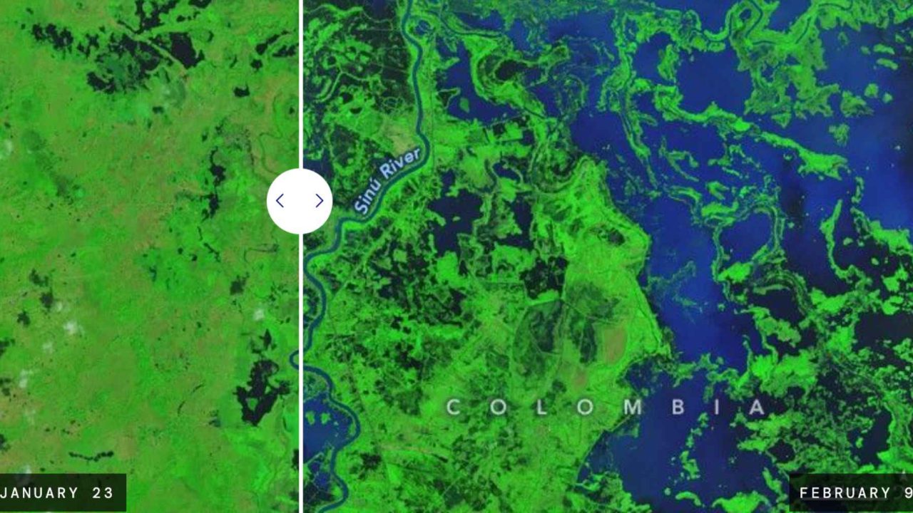
What the Satellite Images Actually Showed
The scale of the flooding became undeniable when viewed from space. NASA’s Earth observation systems captured imagery showing large areas of Córdoba submerged under floodwater — a visual that made the transformation of the landscape impossible to dismiss as a localized or minor event.
From above, the region appeared to have gained an entirely new body of water. Fields that should have been dry and ready for preparation, pastures where cattle would normally be grazing, and communities near the Sinú River all disappeared beneath the flood’s reach.
The Sinú River, which runs through the heart of Córdoba, plays a central role in the region’s agriculture and hydrology. When its surrounding floodplains — typically drying out at this time of year — instead filled with water, the effect rippled outward across the entire agricultural system of the department.
The Conditions That Made This Flooding Possible
Understanding how February 2026 went so wrong requires looking at the chain of events that led up to it.
| Factor | Normal February Conditions | February 2026 Conditions |
|---|---|---|
| Rainfall level | One of the driest months of the year | Intense, unusual rainfall following a wet January |
| Atmospheric driver | Typical dry-season pressure patterns | Unusual Caribbean cold front pushing moisture inland |
| Soil conditions | Drying out from previous dry months | Already saturated from above-normal January rains |
| Floodplain status | Drying, suitable for cattle grazing | Submerged under widespread floodwater |
| Visibility from space | Normal agricultural landscape | Resembled a large inland lake in satellite imagery |
Who Bears the Cost of a Flood Nobody Planned For
The human and economic toll of out-of-season flooding hits hardest on the people least able to absorb it. For Córdoba’s farmers and ranchers, February is a working month — a time of preparation and movement, not disaster response.
Cattle that would normally be moved onto drying pastures had nowhere dry to go. Cropland that should have been ready for planting was instead sitting under water. Communities near the Sinú River faced the kind of disruption that typically only comes during peak rainy season, but without the seasonal preparation that might have softened the blow.
Córdoba is not a peripheral region in Colombia’s agricultural economy. It is one of the country’s key cattle-raising departments, meaning that disruptions there ripple outward into national food systems and livestock supply chains. When a region this important is hit by flooding during what should be its dry season, the consequences extend well beyond the flooded fields themselves.
What Events Like This Signal Going Forward
The February 2026 flooding in Córdoba is a striking example of how climate variability can upend even the most deeply established seasonal patterns. When a region’s dry month becomes its flood month, the assumptions built into farming calendars, infrastructure planning, and disaster preparedness all come under pressure simultaneously.
The fact that this event was visible from space — that it reshaped the landscape dramatically enough for satellites to document a region that looked nothing like it should — underscores just how significant the departure from normal conditions was. Whether events like this become more frequent is a question that scientists and agricultural planners in Colombia and across the Caribbean basin will need to take seriously.
For the people of Córdoba, the more immediate concern is recovery: restoring pastures, assessing livestock losses, and returning to the agricultural routines that February is supposed to support. The satellite images may fade from the news cycle, but the work of rebuilding what the water took will continue long after the floodwaters recede.
Frequently Asked Questions
Why was February flooding in Córdoba so unusual?
February is normally one of the driest months of the year in Córdoba, making significant flooding during this period highly atypical and unexpected for local farmers and ranchers.
What caused the extreme rainfall in February 2026?
An unusual Caribbean cold front pushed moisture inland following an already wetter-than-normal January, creating conditions intense enough to flood large areas of the department.
Which river was central to the flooding?
The Sinú River, which runs through Córdoba, was central to the event, with surrounding communities and farmland near the river particularly affected by the spreading floodwater.
How was the flooding detected from space?
NASA’s Earth observation systems captured satellite imagery showing large areas of Córdoba submerged under water, making the region resemble a broad inland lake rather than a dry-season agricultural landscape.
Why does flooding in Córdoba matter beyond the local region?
Córdoba is one of Colombia’s most important cattle-raising and agricultural departments, meaning disruptions to its farming operations can affect national food systems and livestock supply chains.
How long did it take for the flooding to transform the landscape?
According to reports, the rainfall was intense enough to redraw the landscape almost overnight, with the transformation occurring over just a few days in early February 2026.


Leave a Reply