
The seafloor above the fault that triggered Japan’s 2011 disaster lurched upward by roughly fifty to seventy meters in a matter of minutes — and for years, scientists couldn’t fully explain how that was even possible. Now, after drilling nearly 8,000 meters beneath the ocean surface, a research team has found the answer buried in a razor-thin layer of ancient clay.
The 2011 Tōhoku earthquake, measuring magnitude 9.1, killed tens of thousands of people, sent walls of water crashing through coastal towns, and triggered the Fukushima Daiichi nuclear disaster — a catastrophe whose consequences are still being felt today. But even given the earthquake’s enormous power, the scale of the tsunami it produced puzzled researchers. The wave was far larger and traveled far further inland than models predicted.
A new study published in the journal Science, led by geologist J. D. Kirkpatrick and colleagues, may finally close that gap in understanding.
What Scientists Found Nearly 8,000 Meters Down
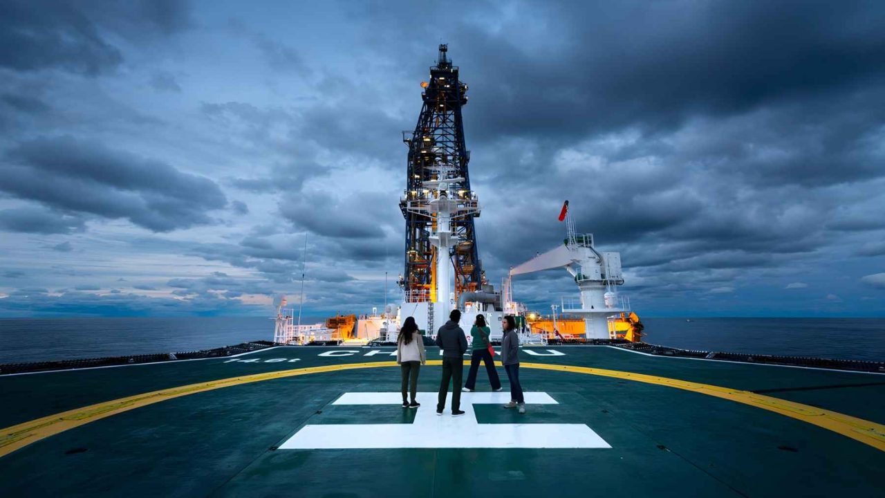
In 2024, an international research team boarded the deep-sea drill ship Chikyu and sailed to the Japan Trench — the underwater canyon system that sits directly above the fault responsible for the 2011 rupture. What followed was one of the most ambitious ocean drilling operations ever attempted.
The team drilled cores from nearly 8,000 meters below sea level, extracting physical samples of the rock and sediment sitting above the fault zone. What they found inside those cores changed the picture entirely.
The rupture in 2011 didn’t tear through solid, resistant rock the way many scientists had assumed. Instead, it raced along a thin layer of ancient clay that was dramatically weaker than the surrounding material. That weakness allowed the fault to slip far more freely — and far more violently — than the geology should have permitted.
That unconstrained slip is what drove the seafloor upward by fifty to seventy meters, displacing an enormous volume of water above it and generating a tsunami of catastrophic scale.
Why the 2011 Tsunami Was So Much Worse Than Models Predicted
Before this research, scientists understood that the 2011 earthquake was powerful. What they struggled to explain was the disproportionate size of the resulting wave. Tsunamis are generated by vertical seafloor movement, and the more the seafloor shifts upward, the more water gets displaced. A fifty-to-seventy-meter upward lurch is extraordinary by any measure.
The ancient clay layer identified in the drill cores provides the missing variable. Because the fault slipped along material with very low resistance, the rupture was able to propagate further and faster than typical fault behavior would allow. The seafloor didn’t just shift — it surged.
This kind of fault behavior, where a weak geological layer enables extreme slip, is sometimes called a “weak fault” mechanism. The Chikyu expedition appears to have produced direct physical evidence of exactly that dynamic playing out beneath the Japan Trench in 2011.
The Ship That Made This Research Possible
The Chikyu is operated by the Japan Agency for Marine-Earth Science and Technology and functions as one of the primary platforms for the International Ocean Discovery Program. It is specifically designed for ultra-deep ocean drilling — the kind of operation no standard research vessel could perform.
The 2024 mission was conducted as part of Expedition 405. Reaching nearly 8,000 meters below sea level to extract usable core samples from above an active fault zone represents a significant technical achievement in its own right.
| Key Detail | Data |
|---|---|
| Earthquake magnitude (2011) | 9.1 |
| Drilling depth | Nearly 8,000 meters below sea level |
| Estimated seafloor uplift during 2011 rupture | 50–70 meters |
| Research vessel | Chikyu |
| Expedition name | Expedition 405 (2024) |
| Study published in | Science journal |
| Lead researcher | J. D. Kirkpatrick |
What This Means for Tsunami Risk Around the World
The implications of this research reach well beyond Japan. Subduction zones — places where one tectonic plate slides beneath another — exist all around the Pacific Rim and in other parts of the world. Many of them sit beneath densely populated coastlines.
If ancient clay layers or similarly weak geological materials exist along other fault zones, those faults could be capable of producing extreme seafloor displacement and outsized tsunamis, even when the triggering earthquake falls within a “normal” expected range. The 2011 disaster showed what that looks like in practice: sea walls that weren’t tall enough, evacuation routes that weren’t fast enough, and models that didn’t account for how far the water would travel.
Researchers and officials have long used the 2011 event as a benchmark for revising tsunami preparedness standards in Japan and elsewhere. This new understanding of the fault’s weak clay layer adds another layer of urgency to those conversations — because it suggests the extreme behavior seen in 2011 was not a fluke. It was geology doing exactly what the conditions allowed.
The findings are also a reminder that the ocean floor still holds information critical to protecting people on land. Drilling programs like Expedition 405 are expensive and technically demanding, but the data they return can rewrite risk assessments for millions of people living near coastlines.
What Comes Next for Fault Zone Research
The cores retrieved during Expedition 405 will likely fuel years of further analysis. Scientists studying fault mechanics, sediment behavior, and tsunami modeling will all have reason to examine what the Chikyu brought back from nearly 8,000 meters down.
Whether similar weak clay layers exist along other high-risk subduction zones — such as those near the Pacific Northwest of the United States, or along the Cascadia fault — remains an active area of investigation. The 2011 disaster made clear that underestimating a fault’s potential is not a theoretical problem. It has consequences that last decades.
Frequently Asked Questions
What caused the 2011 Japan tsunami to be so large?
Research published in the journal Science found that the fault ruptured along a thin, unusually weak layer of ancient clay, allowing the seafloor to lurch upward by roughly fifty to seventy meters and displace an enormous volume of water.
How deep did scientists drill to find this evidence?
The research team aboard the drill ship Chikyu drilled to nearly 8,000 meters below sea level above the Japan Trench fault zone during Expedition 405 in 2024.
Who led the research?
The study was led by geologist J. D. Kirkpatrick and colleagues, and was published in the journal Science.
What is the Japan Trench?
The Japan Trench is an underwater canyon system located off the northeast coast of Japan, sitting directly above the fault that ruptured in the 2011 magnitude 9.1 earthquake.
What ship was used for the expedition?
The deep-sea drill ship Chikyu, operated by the Japan Agency for Marine-Earth Science and Technology, was used as part of the International Ocean Discovery Program’s Expedition 405.
Does this research affect tsunami warnings for other countries?


Leave a Reply