
“`html
An entire lake in northern Quebec essentially vanished overnight in spring 2025 — and the water didn’t just disappear. It carved a brand-new channel through the forest and traveled more than 6.2 miles before pouring into a larger lake. What residents of the Cree community of Waswanipi woke up to find was not a drought, not a slow seasonal change, but something far more sudden and jarring: a lakebed that had been full of water just days before, now reduced to mud, stranded fish, and silence.
The lake in question, Lac Rouge, had long been a favorite fishing spot for the Waswanipi community, known for its sandy shores and reliable catches. By early May 2025, it was nearly gone. NASA satellite imagery later confirmed what locals had already seen with their own eyes — one of the more striking examples of a natural phenomenon called an outburst flood, and a vivid reminder of how quickly a landscape can be rewritten.
How an Entire Lake Disappeared in a Single Night
The first sign that something had gone wrong came from a washed-out logging road northwest of Waswanipi. When community members investigated, they found the answer: the eastern bank of Lac Rouge had collapsed, and the water had found a way out.
Once the breach opened, there was nothing to stop it. Water surged northeast through the forest, punching through a series of smaller ponds along the way before finally reaching Lac Doda, roughly 10 kilometers — about 6.2 miles — away. The entire drainage happened with a speed that left the lakebed nearly dry, save for a few shallow, disconnected pools.
This type of event has a name: an outburst flood. It occurs when a natural dam — formed by sediment, ice, or accumulated debris — suddenly fails, releasing a stored body of water in a rapid, often catastrophic rush. In this case, the failure appears to have been along the lake’s eastern bank, which gave way under pressure and triggered the dramatic chain reaction.
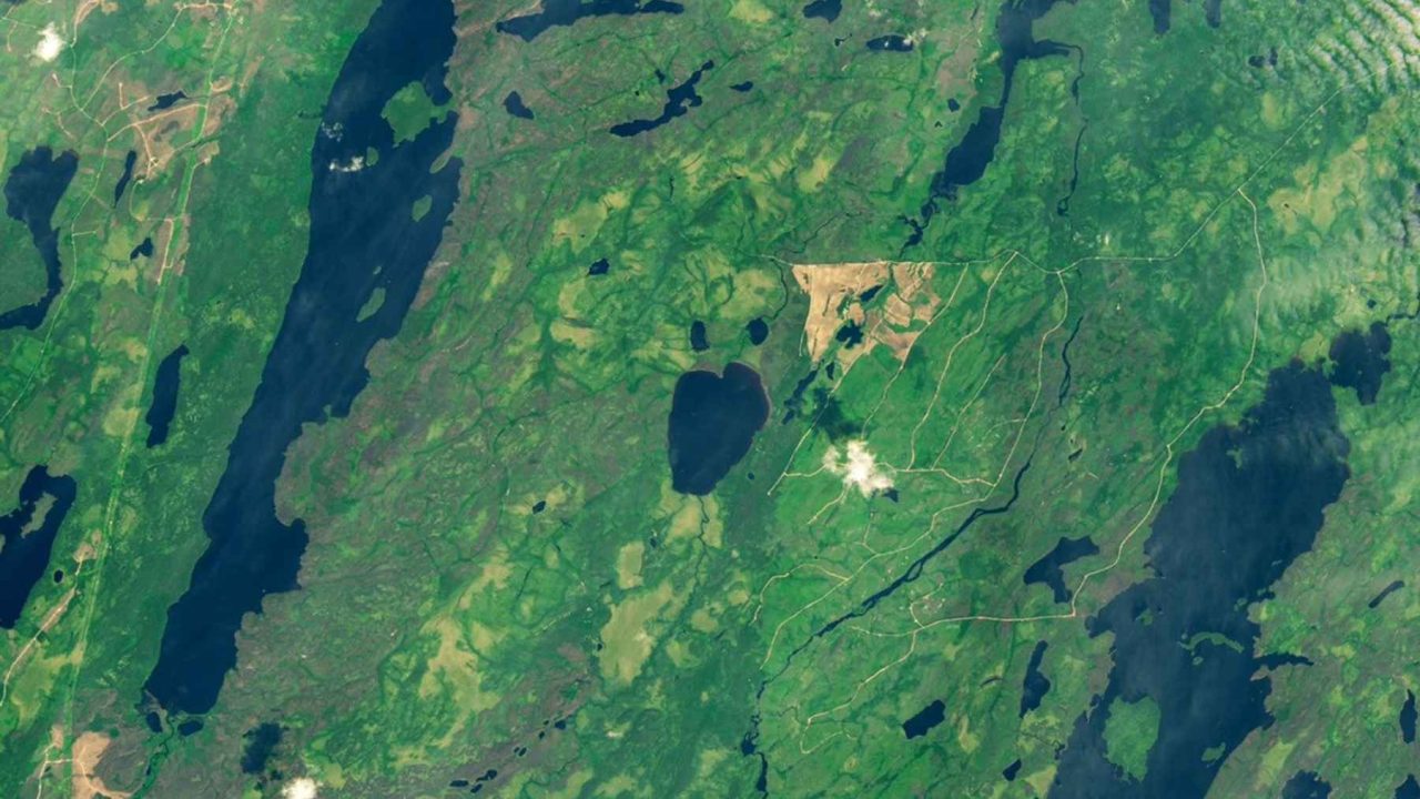
What NASA’s Satellites Showed
The scale of the change became even clearer when NASA Earth Observatory released satellite imagery comparing Lac Rouge across two years. The contrast was stark.
| Year | Appearance of Lac Rouge (Satellite View) |
|---|---|
| 2024 | Dark, heart-shaped lake — full and intact |
| 2025 | Pale basin with a tan sediment streak — nearly empty |
The Landsat 9 images confirmed exactly where the breach had formed and traced the path the water took as it moved northeast. The tan sediment streak visible from orbit is a classic signature of a sudden outburst flood — fine lakebed material left behind as the water drained at speed, exposing the geology beneath.
For scientists who study these events, the imagery was a textbook case. For the people of Waswanipi, it was something else entirely.
What This Meant for the Waswanipi Community
Lac Rouge wasn’t just a body of water on a map. For hunters and trappers in the Cree community of Waswanipi, it was a working part of the landscape — a place people fished, a landmark in a territory they have known for generations.
What they found after the drainage was a scene that was difficult to process. The sandy shores that had made the lake a local favorite were now exposed mud. Dead fish lay across the lakebed, stranded when the water receded too fast for them to follow. The logging road that first alerted people to the event had been washed out by the force of the escaping water.
Events like this carry real consequences for communities whose relationship with the land goes beyond recreation. Fishing spots, travel routes, and ecological knowledge built over decades can be altered or erased in a single night. The washed-out logging road also signals potential disruption to access routes that communities and industries depend on in remote northern regions.
Why Outburst Floods Are Getting More Attention
Outburst floods are not a new phenomenon, but they are drawing increasing scientific attention — particularly in northern and subarctic regions where permafrost, ice, and sediment dynamics are all shifting. When natural dams weaken, whether through thaw, erosion, or the slow buildup of pressure, the results can be sudden and dramatic.
- A breach in a lake’s bank or dam structure can release water almost instantly
- The escaping water carves new channels through whatever terrain it crosses
- Downstream water bodies — like Lac Doda in this case — receive the surge
- The original lake may partially or fully refill over time, or may remain drained
- Satellite monitoring has made it far easier to detect and document these events after the fact
The Lac Rouge event is notable not just for its speed but for how completely it was captured — from the initial community discovery to the NASA orbital confirmation. That combination of ground-level observation and satellite data gives researchers a rare, well-documented case to study.
What Comes Next for Lac Rouge
Whether Lac Rouge will recover is not yet confirmed by the available reporting. Some lakes that experience outburst floods do partially refill as seasonal precipitation and groundwater gradually restore water levels. Others remain permanently altered, their original basins reshaped by the forces that drained them.
The new channel cut through the forest by the escaping water is now a permanent feature of the landscape, at least in the near term. The string of ponds the water passed through on its way to Lac Doda were also affected, their levels and ecology disrupted by the sudden influx.
For the Waswanipi community, the more immediate questions likely involve access — the washed-out logging road still needs to be assessed — and what the loss of a productive fishing lake means for the season ahead. NASA’s continued satellite monitoring of the region means the recovery, or lack of it, will at minimum be visible from orbit.
Frequently Asked Questions
Where did Lac Rouge disappear?
Lac Rouge is located in northern Quebec, near the Cree community of Waswanipi. Its water drained approximately 10 kilometers (about 6.2 miles) northeast into a larger lake called Lac Doda.
When did the lake drain?
The drainage was discovered in early May 2025, when community members investigated a washed-out logging road and found the lakebed nearly empty.
What caused Lac Rouge to drain so quickly?
The eastern bank of the lake collapsed, triggering what scientists call an outburst flood — a sudden, rapid release of water through a breach in a natural dam or bank structure.
How was the event confirmed scientifically?
NASA Earth Observatory released Landsat 9 satellite images comparing the lake in 2024 and 2025, clearly showing the breach, the drainage path, and the tan sediment streak left behind on the exposed lakebed.
Will Lac Rouge refill?
This has not yet been confirmed by available reporting. Some lakes recover partially after outburst floods, while others remain permanently altered — the outcome for Lac Rouge is not yet known.
Who was affected by the lake’s disappearance?
The Cree community of Waswanipi was directly affected. Lac Rouge was a local fishing lake with sandy shores, and hunters and trappers in the area relied on it. A washed-out logging road also disrupted access to the surrounding area.</p


Leave a Reply