
Hidden beneath quiet grazing land on the eastern outskirts of Córdoba, Spain, laser scanning technology has revealed something that historians and archaeologists have been searching for across centuries: geometric patterns buried in the earth that could mark the location of a lost palatine city from the golden age of Al-Andalus.
The discovery — or rather, the tantalizing clue — centers on Madinat al-Zahira, the legendary city built for Almanzor, the powerful chamberlain who effectively ruled the Caliphate of Córdoba at its peak. For generations, this city existed only in historical texts and legend. Now, for the first time, technology is pointing researchers toward a specific location just outside one of Spain’s most storied cities.
From the highway, the hills look like nothing special. A few oaks, some pasture land, the kind of landscape you’d drive past without a second glance. What lies beneath the surface, according to new research, may be one of the most significant archaeological finds in Iberian history.
What the LiDAR Scans Actually Revealed
The research was led by archaeologist Antonio Monterroso Checa at the University of Córdoba. His team analyzed high-resolution LiDAR data collected by Spain’s national mapping agency, the Instituto Geográfico Nacional de España.
LiDAR stands for Light Detection and Ranging. The technology works by firing millions of laser pulses from aircraft toward the ground below. Those pulses bounce back and are measured with extraordinary precision. When specialists digitally remove trees, crops, and vegetation from the resulting model, what remains is the bare shape of the terrain — and anything that may be hidden within it.
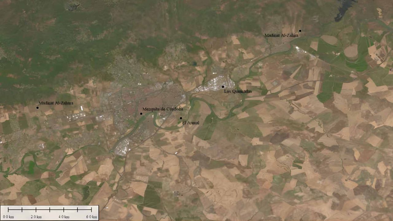
In this case, the terrain told a remarkable story. In the area known as Los Cabezos de las Pendolillas, near the neighborhood of Alcolea and approximately twelve kilometers from Córdoba’s famous mosque-cathedral, the LiDAR model revealed a buried grid of terraces and rectangles. These are not natural formations. Organized geometric patterns like these in the landscape typically signal human construction — walls, foundations, planned streets, the skeleton of a city.
Researchers believe these features could be the physical remains of Madinat al-Zahira, Almanzor’s palatine city, which historical accounts place somewhere near Córdoba but which has never been definitively located.
Who Was Almanzor — and Why Does His Lost City Matter?
To understand why this discovery carries such weight, it helps to know who Almanzor was. At the height of the Caliphate of Córdoba, Almanzor served as the de facto ruler of Al-Andalus, the Muslim-controlled territory of the Iberian Peninsula. He was one of the most powerful political and military figures of medieval Europe, and his influence over the caliphate was so total that the caliph himself was largely a figurehead during his reign.
Like other rulers of the era, Almanzor built his own palatine city — a grand administrative and residential complex separate from Córdoba itself. This was not unusual. The caliphate’s most famous palatine city, Medina Azahara, was built by Caliph Abd al-Rahman III and has been excavated and partially restored. It is now a UNESCO World Heritage Site.
Madinat al-Zahira was Almanzor’s answer to Medina Azahara — his own statement of power and legitimacy. Historical sources confirm it was built and that it was significant. What they have never been able to confirm is exactly where it stood. After the collapse of the caliphate in the early eleventh century, the city was reportedly destroyed, and its location was gradually lost to time and landscape.
Finding it would fill one of the most significant gaps in the history of medieval Iberia.
Key Facts at a Glance
| Detail | Information |
|---|---|
| Lead researcher | Antonio Monterroso Checa, University of Córdoba |
| Technology used | LiDAR (Light Detection and Ranging) |
| Data source | Instituto Geográfico Nacional de España |
| Site location | Los Cabezos de las Pendolillas, near Alcolea |
| Distance from Córdoba city center | Approximately 12 kilometers east |
| Target identification | Buried grid of terraces and rectangles |
| Suspected site | Madinat al-Zahira, palatine city of Almanzor |
- The landscape currently appears as quiet dehesa — oak-dotted grazing land
- The site sits roughly twelve kilometers from Córdoba’s mosque-cathedral
- LiDAR strips away vegetation digitally, exposing ground-level features invisible to the naked eye
- Geometric patterns in the terrain are consistent with planned human construction
Why This Matters Beyond the Headlines
Archaeological discoveries like this one ripple outward in ways that go far beyond academic journals. If the site is confirmed as Madinat al-Zahira, it would represent one of the most significant finds in Spanish medieval archaeology in decades — comparable in cultural weight to the ongoing excavation of Medina Azahara itself.
For the region of Andalusia, it could mean a new major heritage site, new investment in preservation, and a deeper understanding of how the Caliphate of Córdoba functioned at its peak. Córdoba during the caliphate’s height was one of the largest and most sophisticated cities in all of Europe. Recovering a lost piece of that world would reshape how historians understand the period.
More broadly, this story is a reminder of what modern technology is doing for the ancient past. LiDAR has already transformed archaeology in places like Cambodia, Guatemala, and the United Kingdom, revealing cities, road networks, and monuments that centuries of ground-level searching had failed to find. Spain’s national laser mapping data is now proving equally powerful in the hands of researchers who know how to read it.
What Comes Next for the Córdoba Site
LiDAR analysis, however striking, is not confirmation. The geometric patterns identified near Alcolea are a compelling lead — the strongest one researchers have had for Madinat al-Zahira — but the buried features will need to be investigated through traditional archaeological methods before any definitive claims can be made.
That typically means ground surveys, test excavations, and careful stratigraphic analysis to determine whether the buried structures date to the right period and match the historical descriptions of Almanzor’s city. This kind of work takes time and funding, and no timeline for ground excavation at the site has been confirmed in the research as reported.
What the LiDAR analysis has done is give archaeologists a precise target for the first time. After centuries of legend and speculation, that alone is a significant step forward.
Frequently Asked Questions
What is Madinat al-Zahira?
Madinat al-Zahira was a palatine city reportedly built by Almanzor, the powerful ruler of the Caliphate of Córdoba, at the height of his power. Its location has been unknown for centuries.
Who led the research that identified the possible site?
The research was led by archaeologist Antonio Monterroso Checa at the University of Córdoba, using LiDAR data from Spain’s Instituto Geográfico Nacional de España.
What exactly did the LiDAR scans find?
The scans revealed a buried grid of terraces and rectangles in the area known as Los Cabezos de las Pendolillas, near the neighborhood of Alcolea, approximately twelve kilometers east of Córdoba’s mosque-cathedral.
Does this confirm that Almanzor’s lost city has been found?
No. The LiDAR findings are a strong lead, but confirmation would require ground surveys and physical excavation to verify the age and nature of the buried structures.
How does LiDAR technology work in archaeological research?
LiDAR fires millions of laser pulses from aircraft and measures how they return from the ground. Specialists digitally remove vegetation from the resulting model, revealing the bare terrain and any buried features within it.
Where exactly is the suspected site located?
The site is in the Los Cabezos de las Pendolillas area near the Alcolea neighborhood, roughly twelve kilometers from central Córdoba, in terrain that currently appears as ordinary dehesa grazing land.


Leave a Reply