
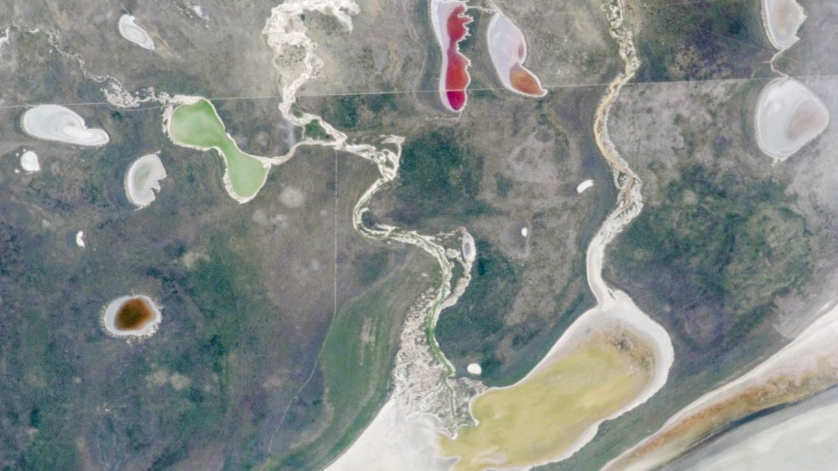
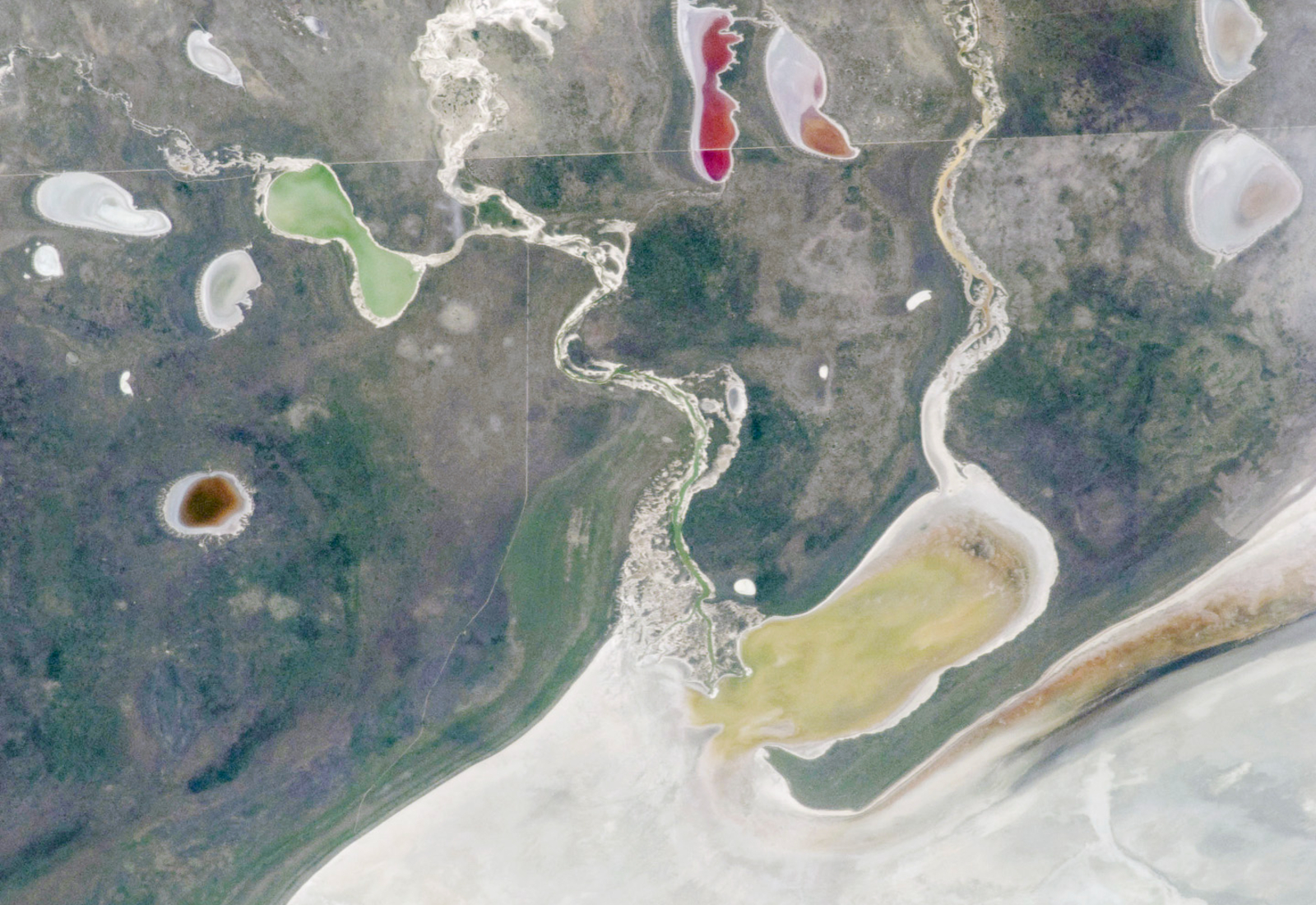
From 250 miles above Earth, an astronaut aboard the International Space Station captured one of the most visually stunning natural phenomena on the planet — a cluster of five brilliantly colored ephemeral lakes that had appeared almost overnight around the edge of one of Africa’s most extraordinary landscapes.
The photograph, taken on December 30, 2011, shows a burst of vivid color against the pale expanse of Namibia’s Etosha Pan — a vast, ancient salt flat in northern Namibia sometimes called the “Great White Place.” The lakes shimmered in shades that seemed almost impossible for a desert environment, the result of a flooding event that temporarily transformed one of the driest corners of southern Africa into something resembling a painter’s palette.
It’s a reminder that Earth’s most dramatic transformations often happen quietly, in remote places, and are only fully visible from space.
What Are Ephemeral Lakes — and Why Do They Look Like That?
Ephemeral lakes are temporary bodies of water that form after significant rainfall or flooding events and then disappear — sometimes within weeks — as the water evaporates or drains away. They are common in arid and semi-arid regions, but few produce the kind of striking visual spectacle captured in this ISS photograph.
The colors in these lakes aren’t an optical illusion or a photographic trick. Shallow, temporary water bodies in salt pan environments develop intense hues because of the unique chemistry at work. As water floods a mineral-rich salt flat, it picks up dissolved salts, minerals, and sediments. Microorganisms — particularly certain species of algae, halophilic bacteria, and other salt-loving life forms — rapidly colonize these shallow pools and produce pigments that can turn the water pink, orange, green, red, or deep violet.
The result, seen from orbit, looks less like a natural landscape and more like something spilled from an artist’s studio.
The Etosha Pan: Africa’s “Great White Place”
The Etosha Pan sits in northern Namibia and is one of the largest salt pans in the world. Its name, drawn from the local Ndonga language, translates roughly to “Great White Place” — a reference to the blinding white salt crust that covers much of its surface during dry periods.
For most of the year, the pan is almost entirely lifeless in appearance: a flat, shimmering expanse of white and grey that stretches to the horizon. But when flooding occurs — as it did in 2011 when a pair of rivers overflowed — the landscape transforms with remarkable speed. Water rushes across the pan’s low-lying edges, pooling in depressions and creating temporary lakes that can persist for weeks or months before the relentless sun reclaims them.
The flooding event captured in the December 2011 image produced five distinct ephemeral lakes arranged around the pan’s perimeter, each displaying its own color signature depending on depth, mineral content, and biological activity.
Key Facts About the ISS Photo and the Etosha Flooding Event
| Detail | Information |
|---|---|
| Location | Etosha Pan, Namibia |
| Coordinates | -18.5946865, 16.04684972 |
| Date photograph taken | December 30, 2011 |
| Photographer | Unnamed astronaut, International Space Station (ISS) |
| Image credit | NASA / ISS program |
| Number of ephemeral lakes visible | Five |
| Cause of lake formation | Flooding from a pair of rivers |
| Type of water body | Ephemeral (temporary) |
The photograph was taken as part of NASA’s ongoing ISS Earth observation program, which has produced thousands of images documenting natural events, weather patterns, and geographic features from orbit. Astronauts aboard the station regularly photograph Earth’s surface, often capturing phenomena that are difficult or impossible to observe from the ground.
Why Images Like This Matter Beyond Their Beauty
There’s an obvious aesthetic appeal to a photograph showing rainbow-colored lakes emerging from a white desert. But images like this one carry scientific and environmental significance that goes well beyond the visual.
Ephemeral lakes in salt pan environments are sensitive indicators of regional climate and rainfall patterns. Their presence, size, color, and duration all provide data about precipitation events, river behavior, and the health of surrounding ecosystems. Scientists studying arid environments use satellite and astronaut photography to track these temporary water bodies over time, building a picture of how conditions are changing across decades.
The Etosha Pan itself is also the centerpiece of Etosha National Park, one of Africa’s premier wildlife reserves. Flooding events around the pan’s edges can temporarily expand habitat for migratory birds and other wildlife, drawing flamingos, pelicans, and other species to the ephemeral shorelines in enormous numbers. The same chemistry that produces those vivid colors also supports blooms of microscopic life that feed filter-feeding birds and fish.
In that sense, what looks like a curiosity from space is actually a brief but vital pulse of ecological activity in one of the continent’s driest regions.
The Bigger Picture: Earth’s Hidden Transformations
The Etosha Pan flooding is one example of a broader phenomenon — landscapes that appear static and barren from the ground revealing themselves to be dynamic and alive when seen from a different perspective, or at a different time.
NASA’s ISS photography program has documented similar temporary lake formations in the Australian outback, the Sahara, and the salt flats of South America. Each event is fleeting. The water comes, the colors bloom, and then — sometimes within a matter of weeks — the land returns to its usual pale stillness, leaving almost no trace that anything happened at all.
That’s part of what makes the December 2011 image so striking. It captured something that existed for only a brief window, in a remote corner of southern Africa, visible in its full glory only from the edge of space.
Frequently Asked Questions
Where exactly were these rainbow-colored lakes photographed?
The lakes appeared around the edge of the Etosha Pan in Namibia, located at coordinates -18.5946865, 16.04684972, in the northern part of the country.
When was the ISS photograph taken?
The photograph was taken on December 30, 2011, by an unnamed astronaut aboard the International Space Station.
What caused the colorful lakes to appear?
The lakes formed after a pair of rivers flooded, sending water across the edges of the Etosha Pan and creating five temporary ephemeral lakes with vivid, contrasting colors.
Why are the lakes different colors?
The varied colors are the result of differences in water depth, dissolved minerals and salts, and biological activity — including microorganisms like algae and halophilic bacteria that produce natural pigments in shallow, mineral-rich water.
Are these lakes permanent features of the landscape?
No. These are ephemeral lakes, meaning they are temporary. They form after flooding events and disappear as the water evaporates, which is common in the arid salt pan environment of the Etosha Pan.
Who is responsible for taking and releasing the photograph?
The image was captured by an unnamed astronaut and released by NASA through its ISS Earth observation program.


Leave a Reply