
There is a sea on Earth with no coastline — no beaches, no cliffs, no borders drawn by land. It is defined entirely by ocean currents, and right now, it is warming at a rate that scientists are watching closely.
The Sargasso Sea sits roughly 590 miles east of Florida, tucked inside a slow-spinning gyre formed by four powerful Atlantic currents. Sail into it and the water changes character — less chop, more stillness, a deep glassy blue that feels nothing like the open ocean around it. Long-term monitoring near Bermuda has recorded a temperature rise of approximately 1.8°F since the 1980s, alongside measurable increases in acidity and drops in oxygen levels.
For a body of water most people have never heard of, the stakes are surprisingly high. The Sargasso Sea functions as one of the Atlantic Ocean’s most important nurseries, and what happens there ripples outward in ways that touch fisheries, climate patterns, and the broader health of the North Atlantic.
A Sea That Has No Shoreline — And Never Did
Most seas are defined by the land that surrounds them. The Sargasso Sea is the only sea on Earth defined entirely by ocean currents. Four of them form its boundaries: the North Atlantic Current to the north, the Canary Current to the east, the North Equatorial Current to the south, and the Antilles Current to the west.
Together, these currents create a rotating system — a gyre — that traps water inside. The result is a body of water that behaves almost like a lake suspended in the middle of the Atlantic. Sailors have described crossing into it as entering a different ocean entirely: calmer, warmer at the surface, and eerily quiet.
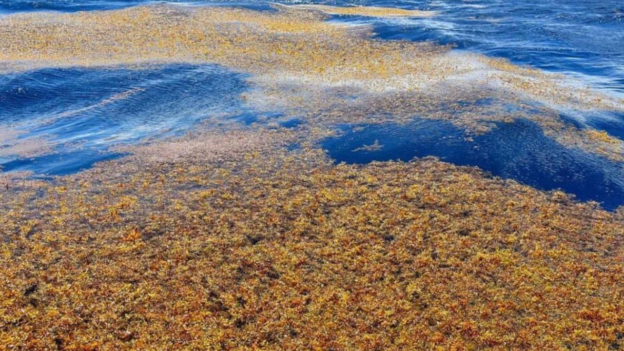
What floats on top of that stillness is what makes the Sargasso truly unusual. Thick mats and drifting streaks of Sargassum — a brown-gold seaweed — cover much of its surface. Early sailors reportedly feared the weed was dense enough to trap and stall ships, though that was more myth than reality. What is real is the ecological role the Sargassum plays. It provides shelter, feeding grounds, and breeding habitat for dozens of species, making it one of the Atlantic’s most productive open-ocean ecosystems.
What the Warming Numbers Actually Mean
A rise of 1.8°F might not sound dramatic. But in ocean terms, sustained warming of that scale over four decades carries serious consequences — especially in a semi-enclosed system like the Sargasso, where water circulation is slower and changes accumulate rather than disperse.
The monitoring data from near Bermuda points to a triple pressure on the ecosystem: rising temperatures, rising acidity, and falling oxygen. Each of those stressors affects marine life differently, and all three are moving in the wrong direction at the same time.
| Observed Change | Detail | Time Frame |
|---|---|---|
| Sea surface temperature increase | Approximately 1.8°F warmer | Since the 1980s |
| Ocean acidity | Rising (increased CO₂ absorption) | Long-term trend |
| Dissolved oxygen levels | Falling | Long-term trend |
| Monitoring location | Near Bermuda | Ongoing |
Warmer water holds less oxygen, which partly explains that third trend. Lower oxygen levels stress fish, reduce habitat for deep-water species, and can trigger cascading effects through the food chain. Rising acidity, driven by the ocean absorbing excess carbon dioxide from the atmosphere, threatens shell-forming organisms at the base of the marine food web.
The Floating Forest Being Cut Apart
The Sargassum seaweed ecosystem — sometimes called a floating forest — is under pressure from more than just warming water. Plastic debris and heavy ship traffic are both documented threats to the Sargasso’s surface habitat.
Because the gyre traps what enters it, plastic waste accumulates in the Sargasso in ways it would not in more open, circulating water. Fishing lines, packaging, and microplastics have been found throughout the Sargassum mats, entangling wildlife and degrading the habitat that juvenile fish, sea turtles, and migratory birds depend on.
Ship traffic adds a different kind of damage — physical disruption of the seaweed mats, noise pollution, fuel discharge, and increased risk of collision with wildlife. The Sargasso sits along major Atlantic shipping routes, meaning the pressure from vessel traffic is not incidental. It is constant.
Why This Matters Beyond the Middle of the Atlantic
The Sargasso Sea’s location — remote, landlocked by currents, with no single country’s coastline touching it — has historically made it difficult to protect. No nation has automatic jurisdiction. International agreements that apply to coastal waters do not automatically extend to the open ocean in the same way.
That governance gap matters because the Sargasso is not just a local ecosystem. It is a critical nursery for species including the European eel and the American eel, both of which migrate thousands of miles to breed there. Declines in the Sargasso’s health translate into declines in fish populations that matter to fishing communities and food systems on both sides of the Atlantic.
The combination of warming, acidification, oxygen loss, plastic accumulation, and ship traffic represents a set of compounding threats — each manageable in isolation, but much harder to reverse when they are all operating simultaneously on the same ecosystem.
What Comes Next for the World’s Only Landlocked Open-Ocean Sea
Monitoring near Bermuda continues to track the long-term changes in water chemistry and temperature. The data collected there represents some of the most detailed long-term records of open-ocean change in the Atlantic, and researchers rely on it to understand how the broader North Atlantic is shifting.
What The threats are documented. The trends are measurable. Whether coordinated action follows remains an open question.
What is clear is that a sea most people cannot find on a map is quietly signaling some of the same pressures reshaping oceans worldwide — and doing so from a place that has no natural advocate in the form of a coastline, a country, or a government with obvious reason to act.
Frequently Asked Questions
Where exactly is the Sargasso Sea?
The Sargasso Sea is located in the North Atlantic Ocean, approximately 590 miles east of Florida. It has no land borders and is defined entirely by four surrounding ocean currents.
How much has the Sargasso Sea warmed?
Long-term monitoring near Bermuda shows the Sargasso Sea has warmed by approximately 1.8°F since the 1980s, alongside rising acidity and falling oxygen levels.
What is Sargassum and why does it matter?
Sargassum is a brown-gold seaweed that floats in mats across the surface of the Sargasso Sea. It provides critical habitat and nursery grounds for numerous Atlantic species, making it one of the ocean’s most important open-water ecosystems.
What threats is the Sargasso Sea currently facing?
The sea faces warming temperatures, increased acidity, declining oxygen levels, accumulating plastic debris, and disruption from heavy ship traffic passing through the region.
Which currents define the boundaries of the Sargasso Sea?
The four currents are the North Atlantic Current, the Canary Current, the North Equatorial Current, and the Antilles Current. Together they form the gyre that encloses the sea.
Is there any international protection for the Sargasso Sea?
Its lack of a coastline means no single nation has automatic jurisdiction over it.


Leave a Reply