
“`html
Scientists have just pulled the longest sediment core ever recovered from beneath an ice sheet — a frozen record stretching back roughly 23 million years — and what those ancient layers contain could fundamentally change how we predict future sea level rise for coastlines around the world.
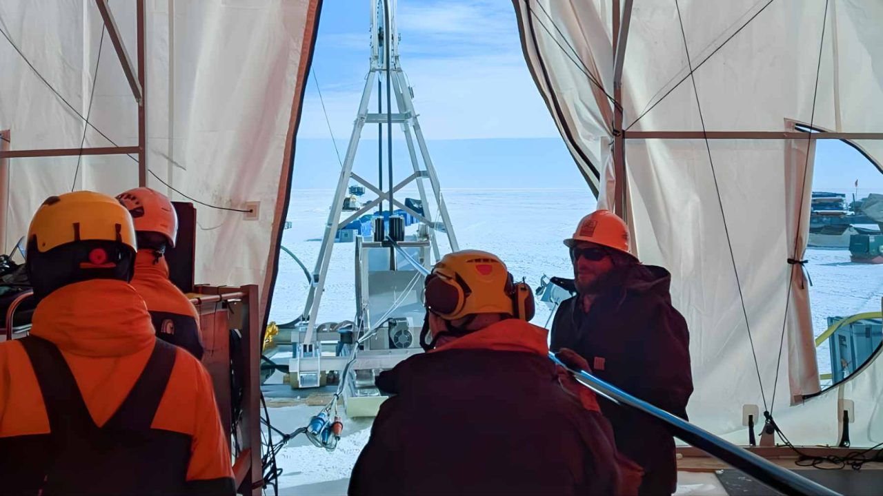
The achievement belongs to an international research team working on the SWAIS2C project, a scientific effort focused on understanding how sensitive the West Antarctic Ice Sheet is to approximately 2 degrees Celsius of global warming. To get their hands on this record, they first had to melt through about 523 meters of ice — roughly 1,716 feet — using water heated to 167°F, then drill a further 228 meters into the bedrock below.
What came back up was approximately 218 meters of ancient mud and stones. That tube of frozen sediment is now one of the most scientifically valuable objects on the planet.
What the SWAIS2C Project Is Actually Trying to Answer
The question at the heart of this research sounds simple but carries enormous weight: if global temperatures rise by around 2°C above pre-industrial levels — a threshold the world is already approaching — how much of the West Antarctic Ice Sheet could collapse, and how fast?
The answer directly determines how much sea levels rise globally. Coastal cities, ports, and low-lying communities from Miami to Mumbai have a stake in that number. Even a partial collapse of the West Antarctic Ice Sheet could push sea levels up by several meters over coming centuries, flooding infrastructure that took generations to build.
The sediment core recovered by the SWAIS2C team is significant precisely because it appears to record periods in Earth’s deep past when this part of Antarctica was not covered in ice at all — when it was open ocean. Those ancient warm periods, preserved in layers of mud and rock, offer a direct window into what happens to this region when temperatures climb.
Researchers believe these sediment layers capture roughly 23 million years of climate history, making them an extraordinary archive of how Antarctic ice has responded to changing temperatures over geological timescales.
Drilling Through 1,716 Feet of Ice in One of the Most Remote Places on Earth
Getting to this sediment was not straightforward. The drill site sits on Crary Ice Rise, a dome of ice grounded on bedrock near the inner margin of the Ross Ice Shelf in West Antarctica. It is more than 700 kilometers from Scott Base, the nearest research station.
That kind of distance in Antarctica is not like driving 700 kilometers on a highway. Everything the team needed — fuel, food, and a custom-built drill system — had to be hauled across the ice on tractor traverses. The logistics alone represent a significant undertaking before a single meter of drilling begins.
The drilling technique itself involved melting down through the ice using water heated to 167°F, creating a borehole through which the drill could then descend into the bedrock below. The team ultimately penetrated 228 meters into the rock beneath the ice sheet to recover their sediment record.
What the Numbers Look Like
| Measurement | Value |
|---|---|
| Ice thickness drilled through | ~523 meters (~1,716 feet) |
| Depth drilled into bedrock below ice | ~228 meters |
| Sediment core recovered | ~218 meters |
| Climate history potentially recorded | ~23 million years |
| Water temperature used to melt through ice | 167°F |
| Distance from nearest research station (Scott Base) | More than 700 kilometers |
The scale of what was accomplished here is hard to overstate. No team had previously recovered a sediment core of this length from beneath an active ice sheet. The record it contains is correspondingly rare.
Why Ancient Mud Matters to People Living on Coastlines Today
It might seem like a stretch to connect 23-million-year-old Antarctic sediment to a beach house in Florida or a port in Bangladesh. But the logic is direct.
The layers of mud and stone in this core appear to include deposits from times when the West Antarctic Ice Sheet had partially or fully collapsed — periods when global temperatures were warmer and this region was open water rather than frozen land. By studying those layers in detail, scientists can reconstruct the conditions that caused past collapses and compare them to where the climate is heading now.
That comparison gives researchers something they cannot get from computer models alone: real physical evidence of how this ice sheet has behaved under warm conditions in the past. It is the difference between a simulation and a historical record.
The SWAIS2C project was specifically designed to probe the 2°C warming threshold because that is the upper limit set by the Paris Agreement — and because it is a temperature range where scientists believe the West Antarctic Ice Sheet becomes particularly vulnerable. Evidence from the sediment core about what happened during comparable past warm periods could sharpen projections that currently carry wide uncertainty ranges.
What Comes Next for This Research
Recovering the core is only the beginning. The real scientific work involves analyzing those 218 meters of sediment layer by layer — identifying the types of material present, dating each section, and reconstructing the environmental conditions that produced each deposit.
Results from projects of this scale typically take months to years to work through, as samples are shared with laboratories around the world for independent analysis.
What the scientific community is watching for most closely is confirmation of how frequently, and under what temperature conditions, this part of Antarctica transitioned from ice-covered to open ocean — and whether those thresholds fall within the range of warming that current emissions trajectories are producing.
Frequently Asked Questions
What is the SWAIS2C project?
SWAIS2C is an international scientific project studying how sensitive the West Antarctic Ice Sheet is to approximately 2 degrees Celsius of global warming, with a focus on understanding potential sea level rise consequences.
Where exactly was the drilling carried out?
The drill site is located on Crary Ice Rise, a dome of ice grounded on bedrock near the inner margin of the Ross Ice Shelf in West Antarctica, more than 700 kilometers from Scott Base.
How did scientists drill through the ice?
The team melted through approximately 523 meters of ice using water heated to 167°F, then continued drilling a further 228 meters into the bedrock below to recover the sediment core.
How old is the climate record contained in the sediment core?
The recovered sediment — approximately 218 meters of ancient mud and stones — appears to record around 23 million years of climate history.
Why does this sediment core matter for sea level rise predictions?
The layers appear to include deposits from periods when this part of Antarctica was ice-free open ocean, providing physical evidence of how the ice sheet has responded to warm conditions in the past.</p


Leave a Reply