
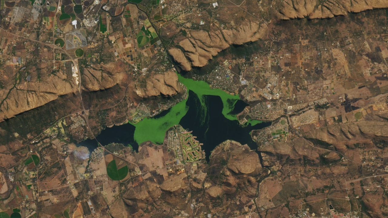
From space, it looks almost beautiful — a vivid, electric-green mass spreading across the surface of a South African reservoir like a living painting. But what NASA’s Landsat 8 satellite captured on August 10, 2022, at Hartebeespoort Dam in South Africa’s North West province is far from harmless. It’s a warning sign visible from orbit.
The image shows toxic algae and invasive aquatic plants blanketing the reservoir’s surface in a dense, verdant sprawl. This is not a rare or unusual sight at Hartebeespoort. According to the source image data, these vibrant blooms frequently cover the reservoir — a pattern that tells a troubling story about the health of one of South Africa’s most recognizable bodies of water.
The dam sits at coordinates approximately -25.74° latitude, 27.86° longitude, and the satellite photo captures just how completely the water’s surface can be overtaken. What looks striking from hundreds of miles above is, at ground level, a serious environmental and public health concern.
What Is Actually Growing in Hartebeespoort Dam
The green mass visible in the Landsat 8 image is a combination of toxic algae — most likely cyanobacteria, commonly called blue-green algae — and invasive aquatic plants. Together, they form what scientists call a bloom: a rapid, dense overgrowth that chokes the water’s surface.
Cyanobacteria blooms are particularly dangerous. They can produce toxins harmful to humans, animals, and fish. Contact with affected water can cause skin irritation, respiratory problems, and in severe cases, liver damage. Animals that drink from bloom-affected water have been known to die. The word “deadly” in the description of this image is not an exaggeration.
Invasive aquatic plants compound the problem. They compete with native species, reduce oxygen levels in the water, and create conditions that allow algae to thrive even further. Once established, these plants are extraordinarily difficult to remove.
Why Hartebeespoort Dam Keeps Making Headlines
Hartebeespoort Dam is not a remote, forgotten reservoir. It sits in a heavily populated region of South Africa, surrounded by residential areas, tourism developments, and agricultural land. The dam has historically been used for recreation — boating, fishing, and tourism — and communities in the area depend on it.
The fact that blooms like the one captured in August 2022 occur frequently, not occasionally, signals a chronic environmental problem rather than a one-off event. Nutrient pollution from agricultural runoff, sewage discharge, and urban development feeds the algae, giving it the fuel it needs to explode across the surface.
When a body of water reaches this stage — where satellite imagery routinely captures it glowing green from space — it has crossed a threshold that is very hard to walk back from without major, sustained intervention.
The Satellite That Caught It All on Camera
The image was captured by Landsat 8, a joint NASA and U.S. Geological Survey satellite that has been orbiting Earth since 2013. It is part of the longest continuous space-based record of Earth’s land surface, dating back to 1972.
Landsat satellites are particularly valuable for environmental monitoring precisely because they revisit the same locations repeatedly over decades. That means scientists can compare what Hartebeespoort Dam looked like years ago versus today — and the trend lines are rarely encouraging for water bodies experiencing this kind of pressure.
| Detail | Information |
|---|---|
| Location | Hartebeespoort Dam, North West Province, South Africa |
| Coordinates | -25.74486936, 27.858152164 |
| Satellite | Landsat 8 (NASA) |
| Date of Image | August 10, 2022 |
| What Is Visible | Toxic algae bloom and invasive aquatic plants |
| Frequency of Blooms | Frequent — described as a recurring pattern |
The Real-World Consequences for People and Wildlife
For communities living around Hartebeespoort Dam, these blooms are not just an eyesore. Toxic algae can render water unsafe for swimming, irrigation, and in some cases even treated drinking water. Pets and livestock that access the shoreline face genuine risk of poisoning.
Fishing, which many local residents rely on for food and income, is severely affected. Fish kills — events where large numbers of fish die due to oxygen depletion caused by algae — are a documented consequence of blooms like this one. The tourism economy built around the dam also suffers when the water looks and smells the way a heavy algae bloom makes it look and smell.
Ecologically, the invasive plants visible in the satellite image displace native aquatic vegetation, disrupt food chains, and alter the physical structure of the reservoir in ways that can persist for years even after the plants themselves are removed.
What Needs to Happen — and Why It’s Complicated
Addressing the problem at Hartebeespoort Dam requires tackling the root causes, not just the symptoms. That means reducing the nutrient load flowing into the reservoir — primarily nitrogen and phosphorus from agricultural runoff and inadequately treated sewage. It also means sustained, large-scale removal of invasive plant species.
Efforts to clean up the dam have been ongoing for years, but the scale of the challenge is significant. Environmental advocates have long argued that without addressing upstream pollution sources, any cleanup effort is essentially a temporary measure. The algae and invasive plants will return as long as the conditions that fuel them remain in place.
Satellite imagery like the Landsat 8 photo from August 2022 plays a genuine role in keeping pressure on this issue. When the scale of a bloom is visible from space, it becomes difficult to minimize or ignore. These images serve as a form of accountability — a regular, objective record of whether conditions are improving or getting worse.

Frequently Asked Questions
Where exactly is Hartebeespoort Dam?
It is located in South Africa’s North West province, at coordinates approximately -25.74° latitude, 27.86° longitude.
What satellite took the image of the algae bloom?
The image was captured by NASA’s Landsat 8 satellite on August 10, 2022.
Is the algae at Hartebeespoort Dam actually toxic?
Yes — the bloom includes toxic algae, which can be harmful to humans, animals, and aquatic life.
How often do these blooms occur at Hartebeespoort Dam?
According to the source data, vibrant algae and invasive plant blooms frequently cover the reservoir’s surface — this is a recurring pattern, not a one-time event.
What is causing the blooms?
The source confirms the presence of toxic algae and invasive aquatic plants. The broader scientific context points to nutrient pollution from agricultural and urban sources as a primary driver of such blooms, though specific local causes were not detailed in
Can the dam be cleaned up?
This has not been specifically addressed in Environmental efforts at the dam have been reported over the years, but the recurring nature of the blooms visible from satellite imagery suggests the problem remains unresolved.

Leave a Reply