
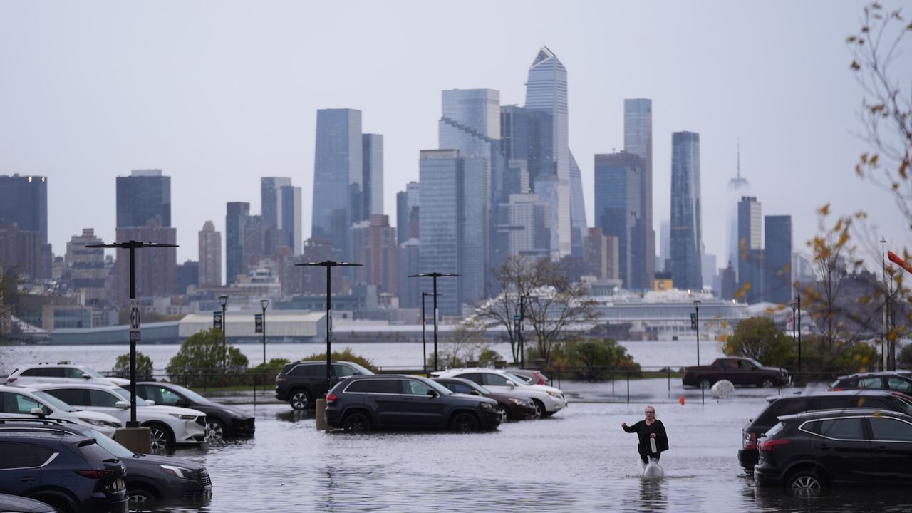
Half of New York City’s entire population — roughly 4.4 million people — could be exposed to extreme flood damage under current risk scenarios, according to a new study examining flood vulnerability along the U.S. East Coast. That figure alone makes New York the most exposed city on the entire Eastern Seaboard, both in terms of the number of people at risk and the number of buildings that could be affected.
The findings land at a moment when coastal flooding is no longer a distant, abstract threat. For millions of New Yorkers, the question isn’t whether flooding will become a serious problem — it’s how serious, and how soon.
New York isn’t alone on this list. New Orleans is also identified as facing some of the greatest dangers among East Coast cities. But the sheer scale of New York’s exposure — driven by its dense population and sprawling built environment — puts it in a category of its own when it comes to the absolute number of people and structures at risk.
What the Study Actually Found
The research identified eight U.S. East Coast cities that are currently at high or very high risk of extreme flood damage. The study assessed risk based on existing conditions, not just future projections — meaning the danger isn’t hypothetical. It’s baked into the current landscape.
New York City stood out for a specific reason: its combination of population density and building stock creates an outsized exposure problem. When researchers looked at which cities had the largest absolute number of people and buildings in the path of extreme flood events, New York topped the list by a significant margin.
New Orleans, a city with a long and painful history of catastrophic flooding, was also flagged as facing some of the gravest risks. The pairing of these two cities — one a dense northeastern metropolis, the other a low-lying Gulf Coast city — illustrates that flood vulnerability cuts across geography and takes different forms depending on local conditions.
New York City’s Flood Risk by the Numbers
The numbers tied to New York City’s flood exposure are striking on their own. Here’s what the study confirmed:
- 4.4 million people in New York City are at risk of being exposed to extreme flood damage
- That figure represents approximately 50% of New York City’s total population
- New York had the largest absolute number of people at high risk of any city studied along the East Coast
- New York also had the largest absolute number of buildings at high risk of extreme flood damage
- Eight East Coast cities total were identified as being at high or very high flood risk under current scenarios
- New Orleans was identified alongside New York as facing some of the greatest dangers
| City | Risk Level | Notable Exposure Factor |
|---|---|---|
| New York City | High / Very High | 4.4 million people (50% of population); highest absolute number of people and buildings at risk on East Coast |
| New Orleans | High / Very High | Among the greatest dangers identified in the study |
| Six additional East Coast cities | High or Very High | Identified in study; specific city names not confirmed in available source material |
Why New York City Is So Vulnerable to Flooding
New York’s geography has always made it susceptible to flooding. The city sits on a network of islands and waterways, with hundreds of miles of coastline exposed to storm surges, tidal flooding, and increasingly intense rainfall events. Much of the city’s infrastructure — subway tunnels, basements, low-lying neighborhoods — was built in an era when today’s flood conditions weren’t part of the engineering calculus.
The concentration of people and buildings in a relatively small geographic area amplifies the risk dramatically. When a flood event hits a densely populated urban environment, the damage doesn’t scale linearly — it compounds. Displaced residents, waterlogged buildings, and overwhelmed drainage systems all interact in ways that make recovery slower and more expensive.
New Orleans presents a different but equally serious picture. Much of the city sits below sea level, protected by a system of levees and pumps that Hurricane Katrina exposed as dangerously inadequate in 2005. The city has invested heavily in flood infrastructure since then, but its fundamental geographic vulnerability remains.

What This Means for People Living in These Cities
For anyone living or working in New York City, a finding that half the city’s population faces high flood exposure is not an abstract policy concern — it’s a direct statement about property values, insurance costs, emergency preparedness, and long-term quality of life.
Flood damage doesn’t just destroy buildings. It disrupts communities, displaces families, contaminates water supplies, and strains emergency services. In a city as economically complex as New York, the downstream effects of a major flood event ripple outward in ways that affect even residents who live well above the flood line.
Renters in basement apartments, homeowners in low-lying neighborhoods, and small business owners in ground-floor commercial spaces are among those most directly exposed. But the study’s framing — extreme damage to people and buildings — signals that the risk extends across the city’s built environment in ways that touch nearly every sector.
What Comes Next for Flood-Vulnerable Cities
The study’s findings add to a growing body of research pressing city and federal officials to treat coastal flood risk as an urgent, present-day crisis rather than a future problem to be managed gradually. Studies like this one are increasingly being used to inform infrastructure investment decisions, zoning policy, and emergency management planning.
For New York specifically, flood resilience has been an active policy conversation since Hurricane Sandy struck in 2012, causing widespread devastation across low-lying neighborhoods in Brooklyn, Queens, Staten Island, and Lower Manhattan. The city has pursued various coastal protection projects in the years since, but the scale of exposure identified in this new research suggests the work is far from complete.
Whether the findings translate into accelerated action — or remain one more data point in a long list of warnings — will depend on political will, funding, and the pace of planning processes that have historically moved slowly relative to the risks they’re meant to address.
Frequently Asked Questions
How many people in New York City are at risk of extreme flood damage?
According to the study, approximately 4.4 million people — around 50% of New York City’s total population — are at high risk of being exposed to extreme flood damage under current scenarios.
Which cities were identified as having the highest flood risk on the East Coast?
The study identified eight U.S. East Coast cities at high or very high risk of extreme flood damage, with New York City and New Orleans specifically highlighted as facing some of the greatest dangers.
Is New York City the most flood-vulnerable city on the East Coast?
New York had the largest absolute number of people and buildings at high risk of extreme flood damage of all cities studied along the East Coast, making it the most exposed in those specific terms.
Does this study account for future climate change, or is this based on current conditions?
The study’s findings are based on current risk scenarios, meaning the danger identified reflects existing conditions rather than projections alone — though
Was New Orleans included in the study’s findings?
Yes. New Orleans was identified alongside New York City as facing some of the greatest flood dangers among the East Coast cities examined in the research.
What types of damage does “extreme flood damage” refer to in the study?
The study references risk to both people and buildings, though the specific source material available does not provide a detailed breakdown of what damage categories were included in the researchers’ definition of “extreme.”


Leave a Reply