
What if the road itself could make drivers slow down — not because of a camera, a fine, or a flashing sign, but simply because of how it looks and feels beneath the wheels? That is the idea India is now testing on one of its national highways, and it could change how countries think about protecting wildlife near busy roads.
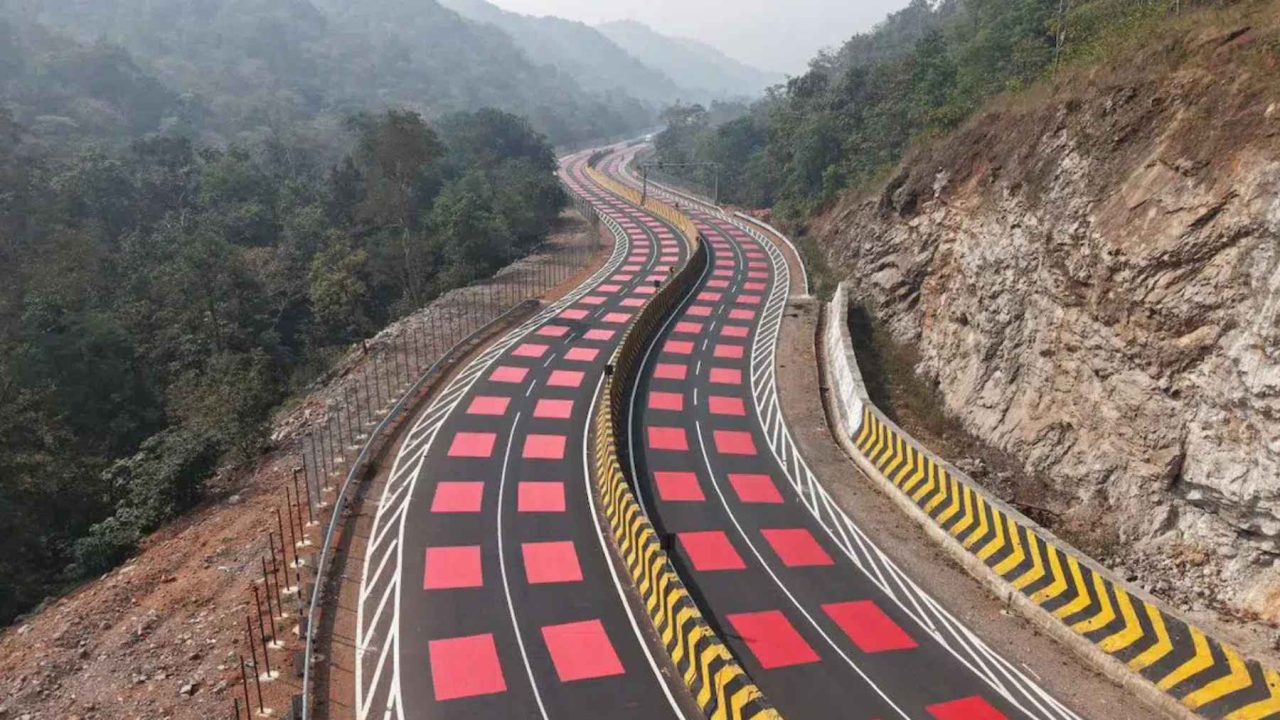
The National Highways Authority of India (NHAI), operating under the Ministry of Road Transport and Highways, has launched what it describes as India’s first “table top red marking” on a highway. The stretch in question runs through the Veerangana Durgavati Tiger Reserve in Madhya Pradesh — and the design is turning heads for good reason.
Roads through wildlife habitat are one of the most persistent and underreported threats to animal populations. Animals do not read warning signs. They do not know that a highway bisects their territory. And drivers, especially at night, often have only a split second to react when something steps into their headlights. This project is an attempt to close that gap with engineering rather than enforcement.
What India’s “Red Road” Actually Is
The project sits on an 11.96-kilometer (roughly 7.4-mile) section of National Highway 45 in Madhya Pradesh. Within that corridor, a 2.0-kilometer (about 1.2-mile) stretch has been treated as a designated danger zone — the area where animal crossings are most likely and where the consequences of a collision are most severe.
Across that danger zone, workers have applied a 5-millimeter hot-applied thermoplastic red surface layer directly onto the road. The color is vivid and unmistakable. From a driver’s perspective, rolling into a section of road that has suddenly turned bright red sends an immediate visual cue: something is different here, pay attention.
The surface is not just about color. Thermoplastic road markings of this type are typically textured, which means they create a subtle change in how the vehicle feels as it passes over them. That combination — visual alarm plus physical sensation — is designed to prompt drivers to ease off the accelerator almost instinctively, without needing a sign, a camera, or a fine to motivate them.
The project also includes dedicated animal underpasses — 25 of them — built into the highway so that wildlife can move beneath the road rather than across it. Fencing runs alongside the corridor to guide animals toward those underpasses rather than onto the open carriageway.
The Key Numbers Behind the Project
| Feature | Detail |
|---|---|
| Highway | National Highway 45, Madhya Pradesh |
| Total project section length | 11.96 km (approx. 7.4 miles) |
| Red surface danger zone length | 2.0 km (approx. 1.2 miles) |
| Red surface layer thickness | 5 mm hot-applied thermoplastic |
| Animal underpasses | 25 dedicated crossings |
| Wildlife reserve | Veerangana Durgavati Tiger Reserve |
| Lead authority | National Highways Authority of India (NHAI) |
The combination of surface treatment, fencing, and underpasses makes this more than a single gimmick. Each element addresses a different part of the problem — slowing drivers, guiding animals, and providing a safe route for wildlife to cross without ever stepping onto the road surface.
Why This Approach Is Different From Fences and Speed Cameras
Speed cameras and warning signs rely on drivers actively reading, processing, and choosing to respond. Fencing alone can redirect animals but does nothing to slow traffic. The red road surface works differently — it triggers a reaction before the driver has consciously decided to do anything.
Supporters of this kind of passive design point out that the most dangerous moments on wildlife corridors happen fast. A tiger, a deer, or a wild boar can appear in seconds. If a driver is already moving at reduced speed because the road surface prompted them to slow down, that extra margin could be the difference between a near miss and a fatal collision — for both the animal and the person behind the wheel.
Officials have noted that this is a first for India in terms of highway design. The NHAI’s decision to deploy it specifically through a tiger reserve signals that the approach is being taken seriously at the infrastructure level, not just as a pilot curiosity.
Who This Affects — and Why It Matters Beyond Madhya Pradesh
The Veerangana Durgavati Tiger Reserve is part of India’s broader network of protected tiger habitats. Tigers, along with leopards, deer, wild boar, and dozens of other species, move through these corridors as part of their natural ranging behavior. A highway cutting through that habitat creates a permanent barrier — and a permanent risk.
India has been expanding its national highway network rapidly in recent years, and that expansion increasingly pushes roads into or near protected areas. The challenge of keeping wildlife safe while maintaining road connectivity is not going away. If the red road design on NH 45 proves effective, it offers a replicable model — one that could be applied to other sensitive stretches across the country without requiring massive structural changes.
For drivers, the practical message is straightforward: in zones marked with red thermoplastic surfacing, the road is telling you to slow down. The design is built to make that feel automatic rather than like an instruction you have to consciously follow.
What Comes Next for This Project
The project on NH 45 is described as India’s first deployment of this specific approach, which means it will almost certainly be watched closely by transport and wildlife authorities for results. Whether animal crossing rates improve, whether collision incidents in the zone decline, and whether drivers actually respond to the surface as intended are all questions that will take time and monitoring to answer.
What is clear is that the project represents a genuine shift in thinking — from enforcement-based solutions toward design-based ones, where the road itself does some of the work.
Frequently Asked Questions
What is India’s “red road” and where is it located?
It is a stretch of National Highway 45 in Madhya Pradesh that features a bright red thermoplastic surface layer applied across a 2.0-kilometer danger zone passing through the Veerangana Durgavati Tiger Reserve.
How does the red surface slow drivers down?
The vivid red color provides a strong visual cue that the road environment has changed, and the textured thermoplastic surface creates a physical sensation underwheel, both of which are designed to prompt drivers to reduce speed instinctively.
How many animal underpasses are included in the project?
The project includes 25 dedicated animal underpasses, allowing wildlife to cross beneath the highway rather than across the road surface.
Who is responsible for this project?
The National Highways Authority of India (NHAI), under the Ministry of Road Transport and Highways, is the lead authority behind the initiative.
Has this approach been used before in India?
According to NHAI, this is India’s first “table top red marking” on a national highway, making the NH 45 project a first of its kind in the country.
Will the red road design be expanded to other highways?
This has not yet been confirmed in the available source material, though the project’s status as a national first suggests it may be evaluated for broader rollout depending on results.


Leave a Reply