
More than 5,200 holes carved into the side of a Peruvian mountain have puzzled researchers for nearly a century — and now, new evidence suggests the answer was hiding in plain sight all along. These weren’t burial pits, defensive fortifications, or ceremonial markers. According to recent research, they may have been something far more practical: an ancient accounting and trade system built directly into the hillside.
The site, known as Monte Sierpe — or “Serpent Mountain” — sits above the Pisco Valley in Peru, and its strange band of pits stretches for almost a mile along a narrow ridge. The sheer scale of it is striking. But what makes the new findings genuinely remarkable is what they suggest about how an ancient Andean society organized its economy without written language or coin-based currency.
This isn’t just an archaeological curiosity. It’s a window into a sophisticated system of record-keeping that rewrites what researchers previously understood about economic life in pre-Columbian Peru.
What the Band of Holes Actually Looks Like
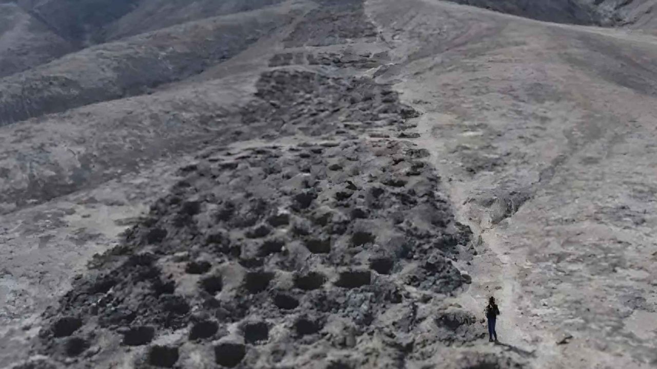
Up close, Monte Sierpe is both orderly and strange. The roughly 5,200 shallow pits are carved directly into the slope of a narrow ridge, each one measuring approximately 3 to 6.5 feet wide and 1.5 to 3 feet deep. From a distance, the band appears nearly continuous — almost like a long, deliberate scar across the hillside.
But when researchers took a closer look using high-resolution drone mapping, the structure revealed itself in new detail. The band isn’t one unbroken line of pits. It’s divided into distinct blocks, separated by open spaces wide enough for people to walk across the ridge. That physical design — walkable gaps between grouped sections — is one of the key clues pointing toward a functional, not ceremonial, purpose.
The drone mapping also exposed something researchers hadn’t been able to confirm before: clear numerical patterns in the arrangement of the holes. Some sections contain long runs of identical rows. Others alternate between specific counts in a repeated sequence. The layout isn’t random. It appears deliberate in a mathematical sense.
The Theory That Changes Everything About the Site
Researchers now believe Monte Sierpe may have functioned as an Indigenous system of trade and accounting, constructed during the Late Intermediate Period — roughly the 1300s. Rather than storing goods underground or marking territory, the pits may have been used to physically count and record quantities of commodities as they were exchanged or distributed.
Think of it as a landscape-scale ledger. In a society without written text, physical space itself could serve as the record. The arrangement of holes — how many in a row, how sections were grouped, which blocks were adjacent to walkways — may have encoded numerical information that participants in a trade system could read and use.
This theory reframes the entire site. For decades, various explanations had been proposed — ritual use, defense, storage — but none fully accounted for the mathematical regularity of the layout. An accounting function fits both the structure and the scale in a way previous theories did not.
Key Facts About Monte Sierpe at a Glance
| Feature | Detail |
|---|---|
| Location | Above the Pisco Valley, Peru |
| Local name | Monte Sierpe (“Serpent Mountain”) |
| Total number of holes | Approximately 5,200 |
| Length of the band | Almost one mile along a ridge |
| Hole width | 3 to 6.5 feet |
| Hole depth | 1.5 to 3 feet |
| Estimated period of construction | Late Intermediate Period, around the 1300s |
| Research method | High-resolution drone mapping |
- The site stretches along a narrow ridge, not a flat plain
- Open gaps between pit blocks allow pedestrian crossings of the ridge
- Numerical patterns are visible in both row counts and section groupings
- The layout appears mathematical rather than random or purely decorative
Why This Matters Beyond Archaeology
The implications here go well beyond a single unusual site. If Monte Sierpe truly served as a physical accounting system, it suggests that pre-Columbian Andean societies developed economic infrastructure that was far more complex and spatially organized than the historical record has typically acknowledged.
Most accounts of ancient Andean economies have focused on the quipu — knotted cords used by the Inca to record numerical data. The idea that an earlier society during the Late Intermediate Period may have embedded similar logic into the physical landscape itself points to a broader tradition of non-written record-keeping that predates Inca dominance in the region.
It also raises questions about how trade actually worked at this scale. A mile-long ridge of counting pits implies organized, repeated transactions — not one-off exchanges. Whatever was being counted at Monte Sierpe, it was being counted consistently and over time, suggesting a structured economy with regular participants and agreed-upon methods of record.
What Researchers Still Don’t Know
The drone mapping has clarified the structure of the site considerably, but significant questions remain. Researchers have not yet confirmed what specific goods were being counted or traded at the site. The identity of the culture responsible for constructing Monte Sierpe during the 1300s has not been definitively established in the current research. And the precise meaning of the numerical sequences embedded in the pit arrangement is still being analyzed.
What the new research does establish is that the site was not accidental, not random, and almost certainly not ceremonial in its primary function. The mathematical regularity of the layout — now documented with drone precision — makes a strong case that Monte Sierpe was a working tool, used by real people conducting real economic activity in the Pisco Valley more than 700 years ago.
Further excavation and analysis will be needed to confirm the accounting theory and to identify which culture built and used the site. But the framework for understanding Monte Sierpe has fundamentally shifted — from mystery to mechanism.
Frequently Asked Questions
Where is the Band of Holes located?
The site, known as Monte Sierpe or “Serpent Mountain,” sits above the Pisco Valley in Peru, stretching nearly one mile along a narrow ridge.
How many holes are there at Monte Sierpe?
Researchers have documented approximately 5,200 shallow pits carved into the hillside.
What is the leading theory about why the holes were dug?
New research suggests the holes may have functioned as an Indigenous system of trade and accounting, with numerical patterns encoded in the arrangement of the pits.
When were the holes created?
The site is believed to date to the Late Intermediate Period, roughly around the 1300s.
How did researchers study the site?
Scientists used high-resolution drone mapping to document the layout of the pits in unprecedented detail, which revealed clear numerical patterns in their arrangement.
What culture built Monte Sierpe?
This has not yet been definitively confirmed in the current research, though the site dates to the Late Intermediate Period in Andean history.


Leave a Reply