
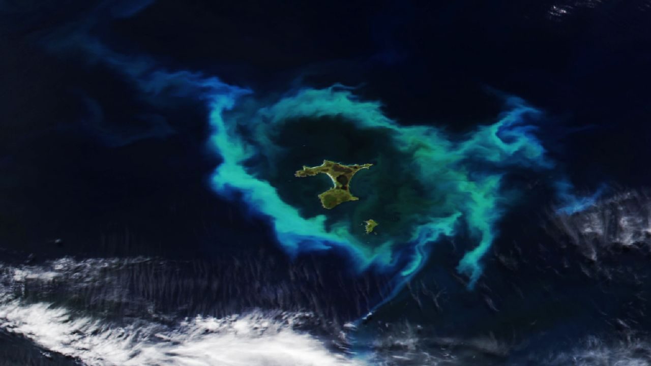
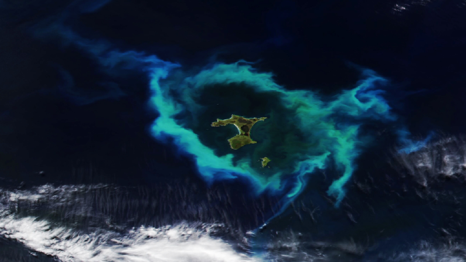
A satellite captured something genuinely strange on January 10, 2026 — a glowing ring of microscopic ocean life encircling a remote island chain in the South Pacific, thousands of miles from nearly anywhere. The image, taken by the NOAA-20 satellite, shows the Chatham Islands of New Zealand wrapped in a bright halo of blooming phytoplankton, visible from space.
It looks almost otherworldly. But the science behind it connects to something far more grounded — and far more troubling. These same islands are known as one of the world’s most dangerous stretches of coastline for whales, a place where strandings happen with disturbing regularity. And the underwater geography responsible for that deadly pattern appears to be the same force shaping the phytoplankton bloom visible from orbit.
This is what Earth looks like when biology and geology collide on a massive scale.
What the Satellite Actually Captured
The image was taken by the NOAA-20 satellite on January 10, 2026, and it shows the Chatham Islands — a remote New Zealand archipelago located at approximately 44°S, 176°W in the South Pacific Ocean — surrounded by what appears to be a luminous ring of color in the water.
That ring is a phytoplankton bloom. Phytoplankton are microscopic, plant-like organisms that drift through the ocean’s surface waters. They photosynthesize sunlight and form the base of nearly every marine food web on Earth. When conditions are right — the right mix of nutrients, light, and temperature — they reproduce explosively, forming blooms large enough to be photographed from space.
What makes this image so striking is the near-perfect circular shape of the bloom around the islands. That’s not a coincidence. It’s a clue about what’s happening beneath the surface.
The Underwater Plateau Driving the Bloom
The Chatham Islands sit above the Chatham Rise, a large underwater plateau that extends east from New Zealand’s South Island. This elevated section of the seafloor has a profound effect on the ocean above it.
As deep, cold, nutrient-rich water moves through the ocean and encounters the rise, it gets pushed upward toward the surface — a process known as upwelling. That surge of nutrients from the deep acts like fertilizer for phytoplankton, triggering the kind of explosive bloom captured in this satellite image.
The same underwater topography that fuels life also creates navigational chaos for marine mammals. The shallow, complex seafloor geometry around the islands is believed to interfere with the echolocation and navigation systems that whales and dolphins rely on, making the Chatham Islands one of the world’s most notorious hotspots for whale and dolphin strandings. The very plateau that feeds the ocean also, tragically, disorients the creatures that depend on it.
Key Facts About the Chatham Islands Phytoplankton Bloom
| Detail | Information |
|---|---|
| Location | Chatham Islands, New Zealand (44.00°S, 176.50°W) |
| What was photographed | A glowing ring of phytoplankton surrounding the archipelago |
| Satellite used | NOAA-20 |
| Date captured | January 10, 2026 |
| Image credit | NASA/NOAA |
| Linked geological feature | Underwater plateau (Chatham Rise) |
| Associated ecological concern | Deadly whale stranding events |
- The Chatham Islands are one of New Zealand’s most remote island groups, situated well east of the South Island in the South Pacific.
- Phytoplankton blooms of this scale are visible from orbit because the organisms contain chlorophyll, which reflects light in distinctive ways detectable by satellite sensors.
- The bloom’s circular halo shape around the islands reflects the influence of the underwater plateau on ocean circulation patterns.
- January in the Southern Hemisphere is midsummer — peak conditions for phytoplankton growth due to increased sunlight and surface water warming.
Why the Chatham Islands Are a Graveyard for Whales
The connection between this bloom and whale strandings is more than coincidental geography. The Chatham Rise and the shallow coastal waters around the islands create a combination of conditions that researchers have long associated with mass stranding events.
Whales and dolphins navigate using echolocation — bouncing sound waves off the seafloor and surrounding terrain to build a mental map of their environment. When that terrain becomes irregular, shallow, or confusing, the system can break down. Animals that become disoriented in these waters can find themselves beached before they have any chance to correct course.
The Chatham Islands have recorded some of the largest mass stranding events in the world. The same nutrient upwelling that creates spectacular phytoplankton blooms also draws in fish and squid, which in turn attract whales — bringing large populations of marine mammals into close proximity with one of the ocean’s most navigationally treacherous zones.
It’s a brutal irony. The richness of the ecosystem draws animals in. The geology of the seafloor traps them.
What Images Like This Tell Us About Ocean Health
Satellite imagery of phytoplankton blooms has become one of the most valuable tools scientists have for monitoring ocean health in real time. Phytoplankton produce roughly half of the world’s oxygen and absorb enormous amounts of carbon dioxide. Tracking where and when they bloom helps researchers understand how climate change is altering ocean chemistry, temperature, and circulation.
Images captured by programs like NASA and NOAA’s joint satellite operations give scientists a continuous, global view of these changes — turning something invisible to the naked eye into a vivid, color-drenched map of ocean productivity.
The January 2026 image of the Chatham Islands is one frame in that ongoing record. It’s beautiful. It’s also a data point in a much larger story about how the ocean is changing, and what those changes mean for everything that lives in it.
Frequently Asked Questions
Where are the Chatham Islands located?
The Chatham Islands are a remote New Zealand archipelago in the South Pacific Ocean, situated at approximately 44°S, 176°W — well east of New Zealand’s South Island.
What satellite took the photo of the phytoplankton bloom?
The image was captured by the NOAA-20 satellite on January 10, 2026, and was credited to NASA/NOAA.
What causes the glowing ring of phytoplankton around the islands?
The bloom is linked to an underwater plateau that pushes nutrient-rich deep water toward the surface, fueling explosive phytoplankton growth visible from space.
Why are the Chatham Islands associated with whale strandings?
The same underwater plateau and complex seafloor geography that drives the phytoplankton bloom is believed to interfere with whale navigation, making the area a notorious hotspot for deadly stranding events.
Are phytoplankton blooms harmful?
Not all blooms are harmful — many, like this one, reflect healthy nutrient upwelling. However, some types of algal blooms can produce toxins dangerous to marine life and humans;
How large was the phytoplankton bloom around the Chatham Islands?
The exact dimensions of the bloom have not been confirmed in the available source material, but it was large enough to be clearly visible from orbit via satellite imagery.


Leave a Reply