
Nearly 3,000 archaeological traces hidden beneath ordinary farmland in northwestern Bohemia — and none of it was visible from the surface. That is the scale of what a team of researchers has uncovered without lifting a single shovel.
Using remote sensing technology, a method that allows scientists to “see” underground structures from the air and the surface without excavating, the team identified 2,918 distinct archaeological features across what appears to be unremarkable agricultural land in Central Europe. Among those features: Neolithic long barrows estimated to be approximately 5,000 years old.
The discovery is forcing a serious reassessment of how much prehistoric history has survived beneath fields we assumed were archaeologically blank.
What Remote Sensing Actually Found Beneath the Fields
The research was led by Petr Krištuf alongside colleagues Tomáš Kroupa, Peter Milo, Jan Havelka, Jan Turek, and Martin Gojda. The project connects three major institutions: the University of West Bohemia in Pilsen, Masaryk University, and Charles University.
Their focus area was northwestern Bohemia, a region where centuries of farming have long been assumed to have erased or severely damaged any trace of prehistoric occupation. What they found instead was a remarkably intact underground record of where ancient people lived — and where they buried their dead.
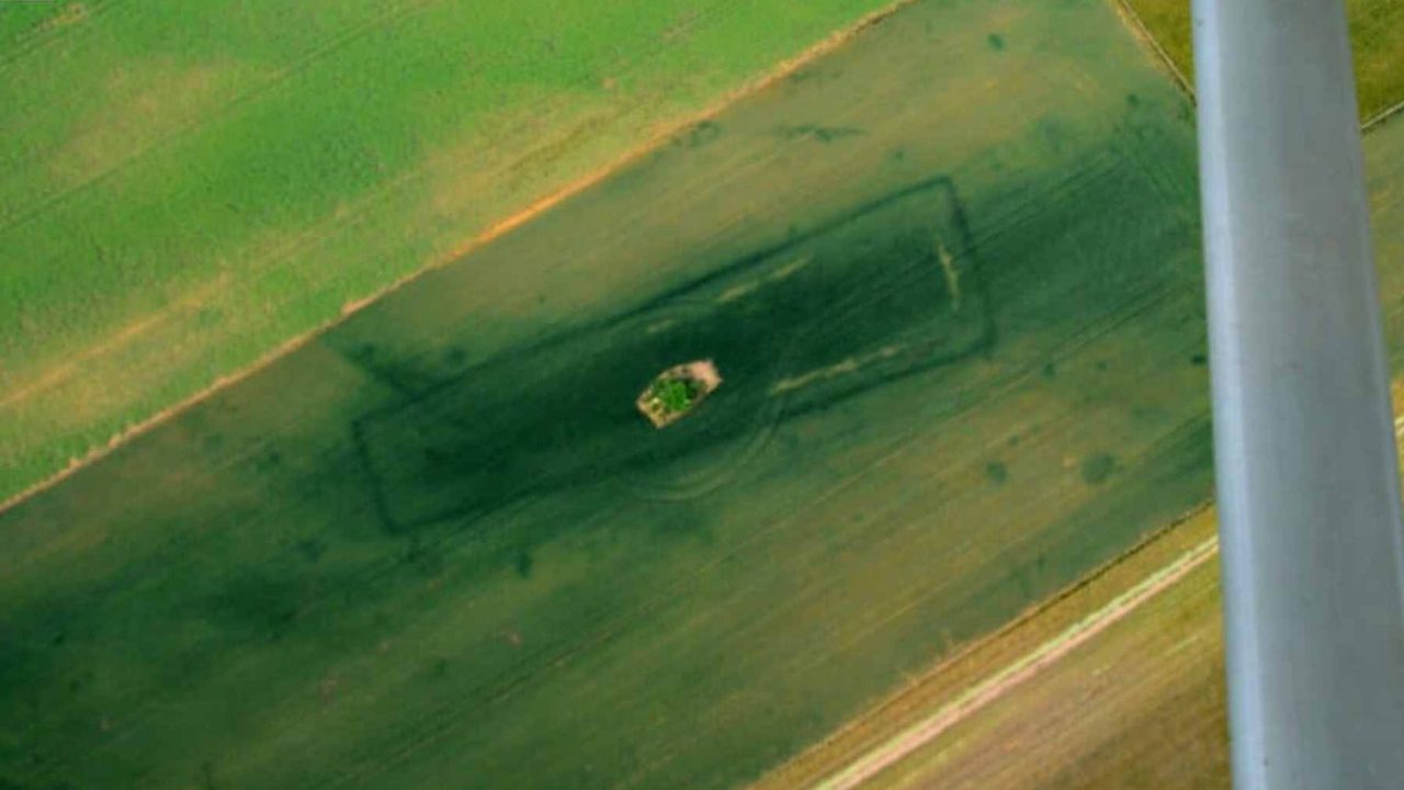
The 2,918 identified features include faint traces consistent with ditches, pits, enclosures, and building remains. These are not random scatterings. The features clustered into four main concentrations, suggesting organized prehistoric land use across the study area.
Most significantly, the team found that the likely settlement zones — where people actually lived — sat physically apart from the funerary zones, separated by roughly 1,600 meters. That kind of deliberate spatial separation between the living and the dead speaks to a level of social and cultural organization that challenges simpler assumptions about Neolithic communities.
Why This Changes How We Think About Neolithic Funerary History
Long barrows are among the most recognizable monuments of the Neolithic period. These elongated earthen mounds were constructed as burial sites and are found across parts of Europe, but identifying them in heavily cultivated land is extraordinarily difficult. Centuries of plowing gradually flatten surface features until they become invisible to the naked eye.
The fact that researchers could detect barrows dating back roughly 5,000 years beneath active farmland — using non-invasive technology — suggests that the archaeological record beneath European fields is far richer than previously assumed.
It also raises an uncomfortable question: how many similar sites have already been permanently damaged or destroyed because no one knew to look? And how many more remain undiscovered simply because the land above them looks like any other field?
The research team’s findings suggest the answer to that second question may be: quite a lot.
Key Facts From the Northwestern Bohemia Discovery
| Detail | Finding |
|---|---|
| Total archaeological features identified | 2,918 |
| Age of Neolithic long barrows found | Approximately 5,000 years old |
| Number of main feature concentrations | 4 |
| Separation between settlement and funerary zones | Approximately 1,600 meters |
| Method used | Remote sensing (non-invasive, no excavation) |
| Lead researcher | Petr Krištuf |
| Institutions involved | University of West Bohemia in Pilsen, Masaryk University, Charles University |
- Features identified include traces of ditches, pits, enclosures, and building remains
- Settlement zones and burial zones were physically and deliberately separated
- The research area is in northwestern Bohemia, Central Europe
- No excavation was required — all findings came from remote sensing alone
What This Means for Farmland Across Europe
Perhaps the most important takeaway from this research is not what was found in Bohemia specifically — it is what this implies about farmland everywhere else.
For decades, heavily cultivated land has been considered a lower priority for archaeological investigation. The assumption was logical: repeated plowing, drainage systems, and modern agricultural activity destroy buried features over time. Why look where so much has already been lost?
This study pushes back against that logic. Even in land that has been worked for generations, the underground record can remain legible. Remote sensing, which gathers data without disturbing the ground, gives researchers a way to read that record without committing to expensive and time-consuming excavations.
The researchers’ core conclusion is pointed: even heavily farmed land still preserves a readable layout of where people lived and where they placed their dead. That is a significant statement for how archaeological surveys should be prioritized going forward — not just in Bohemia, but across Central Europe and beyond.
It also matters for heritage protection. Features that are identified and mapped can be protected. Features that remain unknown are vulnerable to damage from infrastructure projects, deeper plowing, or development — with no one the wiser.
What Comes Next for This Research
The identification of nearly 3,000 features through remote sensing is, in one sense, just the beginning. Non-invasive detection can reveal that something is there; it cannot fully explain what it means without follow-up work.
Targeted excavations at key feature locations would allow researchers to confirm dates, identify artifact assemblages, and build a more complete picture of how Neolithic communities in this part of Bohemia actually organized their lives and their deaths.
The four identified concentrations of features, and the clear spatial logic separating living areas from burial grounds, give researchers well-defined targets for that future work. The underground map has been drawn. The next step is reading it more closely.
For now, the broader significance stands on its own: a field that looked perfectly ordinary from the road turned out to be one of the more archaeologically significant patches of ground in the region — and technology, not a spade, is what revealed it.
Frequently Asked Questions
What did researchers find beneath the farmland in northwestern Bohemia?
Using remote sensing technology, researchers identified 2,918 archaeological features, including Neolithic long barrows approximately 5,000 years old, along with traces of ditches, pits, enclosures, and building remains.
Who led the research team behind this discovery?
The project was led by Petr Krištuf, with colleagues Tomáš Kroupa, Peter Milo, Jan Havelka, Jan Turek, and Martin Gojda, connecting the University of West Bohemia in Pilsen, Masaryk University, and Charles University.
How were these features discovered without digging?
The team used remote sensing, a method that allows researchers to detect underground structures from the air and surface without excavation, making it possible to survey large areas of farmland non-invasively.
What is the significance of the separation between settlement and burial zones?
The settlement area and funerary zones were separated by approximately 1,600 meters, suggesting a deliberate and organized approach to land use among Neolithic communities in the region.
Does this mean other European farmland could be hiding similar sites?
The researchers concluded that even heavily farmed land can preserve a readable underground record, suggesting that other cultivated areas across Central Europe may contain similarly significant undiscovered sites.
Will the site be excavated?


Leave a Reply