

Satellite images now visible from space show oil spreading across the Persian Gulf — the direct result of air strikes that have struck oil facilities and tankers across the region. What looked like a military conflict contained to land and air has now spilled, quite literally, into one of the world’s most strategically and ecologically sensitive bodies of water.
The images tell a stark story. Oil is not just drifting — it is heading toward places that matter deeply: a protected wildlife refuge, coastal communities, and water and food sources that millions of people depend on. The environmental damage from this conflict may outlast the strikes themselves by years, possibly decades.
This is what happens when modern warfare meets fragile ecosystems. And the Persian Gulf, already one of the most heavily trafficked and industrially stressed bodies of water on Earth, may be paying a price that no ceasefire can undo.
What the Satellite Images Actually Show
Two specific images have drawn significant attention from scientists and environmental monitors tracking the situation.
The first, captured on April 6, shows an oil trail leaving a vessel or facility in the Gulf — a visible slick cutting through open water. The second, taken on April 10, is arguably more alarming. It shows oil leaking into the waters off Iran’s Lavan Island and moving toward Shidvar Island, a protected wildlife refuge that has earned the nickname “Iran’s Maldives” for its extraordinary natural beauty and biodiversity.
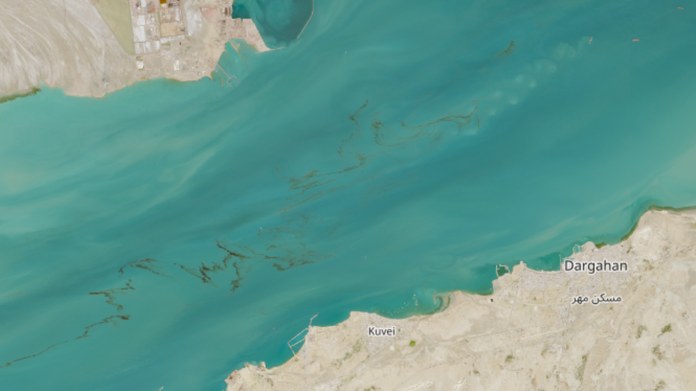
Both images were captured by the Copernicus Sentinel-2 satellite operated by the European Space Agency (ESA) — the same program used to monitor natural disasters, deforestation, and climate change events worldwide. When oil spills are large enough to appear in satellite imagery, the scale of contamination is already significant.
The strikes responsible are attributed to Iranian and U.S.-Israeli air operations that have targeted oil infrastructure and tankers across the region. The result is multiple simultaneous contamination events in one of the world’s most critical maritime zones.
Why Shidvar Island Changes Everything About This Story
Most coverage of conflict in the Persian Gulf focuses on geopolitics, energy markets, and military strategy. The threat to Shidvar Island shifts the lens entirely.
The island is a protected wildlife refuge — meaning it carries legal and conservation status designed specifically to shield it from exactly this kind of damage. It is home to species and ecosystems that took centuries to develop and cannot simply be rebuilt after an oil contamination event.
Oil spills in protected marine areas are particularly catastrophic because the very features that make them worth protecting — biodiversity, clean water, thriving coral or coastal ecosystems — are precisely what crude oil destroys most efficiently. Oil coats feathers, suffocates marine life, poisons food chains, and lingers in sediment for years after the visible slick disappears.
The fact that the April 10 satellite image shows oil actively moving toward Shidvar Island means the contamination may not yet be at its worst. Depending on currents and the volume of the spill, what reaches the refuge in the coming days could be far more than what was visible from orbit on that date.
The Threat to Water and Food Supply
Beyond the wildlife refuge, the broader concern is what oil contamination in the Persian Gulf means for the humans who live and eat along its shores.
The Persian Gulf is a critical source of seafood for coastal populations across Iran, the UAE, Qatar, Bahrain, Kuwait, and Saudi Arabia. Fisheries in the region supply both local food security and export markets. When oil enters these waters, it doesn’t simply float on the surface — it enters the food chain through fish, shellfish, and other marine organisms that communities harvest and consume.
Water supply is equally at stake. Several Gulf states rely heavily on desalination plants that draw directly from Gulf waters. Oil contamination near desalination intake points can force shutdowns, reduce output, or — in worst-case scenarios — compromise the quality of drinking water reaching homes and hospitals.
| Date | Location | What Was Observed | Source |
|---|---|---|---|
| April 6 | Persian Gulf (vessel/facility) | Oil trail visible leaving site | Copernicus Sentinel-2 / ESA |
| April 10 | Off Lavan Island, Iran | Oil leaking, moving toward Shidvar Island wildlife refuge | Copernicus Sentinel-2 / ESA |
Who Bears the Consequences of Oil Spills From This Conflict
It is worth being direct about who actually suffers when oil contaminates a body of water like the Persian Gulf.
It is rarely the governments or military forces involved in the strikes. It is fishing communities who can no longer safely harvest their catch. It is coastal families whose drinking water becomes unreliable. It is the wildlife in protected refuges like Shidvar Island — birds, fish, marine mammals, and coral ecosystems that have no way to relocate or adapt quickly enough.
Environmental damage from oil spills also carries long economic consequences. Tourism, fishing industries, and coastal development in affected areas can take years — sometimes more than a decade — to recover, if they recover at all. The Persian Gulf’s already fragile marine environment, stressed by decades of industrial activity and climate change, has limited resilience to absorb another major contamination event.
What Comes Next — and What Remains Unknown
As of the satellite images available through April 10, the full extent of the spills has not been publicly confirmed. Environmental monitoring organizations and agencies tracking the region through satellite data will be watching closely to assess how far the oil has spread and whether it has reached Shidvar Island’s protected waters.
What is confirmed is that the contamination is real, it is visible from space, and it is moving. The coming days will be critical in determining whether the wildlife refuge sustains a direct hit — and whether emergency containment or cleanup operations are even possible given the ongoing conflict in the region.
Cleanup efforts during active military operations present an obvious problem: the infrastructure, personnel, and international cooperation normally required to respond to a major oil spill are extraordinarily difficult to mobilize when the area is still under threat of further strikes.
The Persian Gulf has survived oil spills before — including catastrophic ones during the 1991 Gulf War. But each event leaves a cumulative toll. Scientists and conservationists who have studied the region for decades have consistently warned that the Gulf’s ecosystems are running out of room to absorb new damage. This latest crisis may test that limit in ways that will take years to fully understand.
Frequently Asked Questions
Where are the oil spills occurring?
Satellite images show oil spills in the Persian Gulf, specifically near Iran’s Lavan Island, with oil moving toward Shidvar Island, a protected wildlife refuge.
What caused the oil spills?
According to satellite data and reporting, the spills are the result of Iranian and U.S.-Israeli air strikes hitting oil facilities and tankers across the region.
What is Shidvar Island and why does it matter?
Shidvar Island is a protected wildlife refuge off Iran’s coast, sometimes called “Iran’s Maldives,” recognized for its exceptional biodiversity and natural environment.
How were the spills detected?
The spills were captured by the Copernicus Sentinel-2 satellite operated by the European Space Agency (ESA), with key images taken on April 6 and April 10.
Could the spills affect drinking water?
Yes — several Gulf states rely on desalination plants that draw from Gulf waters, and oil contamination near intake points can threaten both water supply and quality.
Has cleanup begun?
This has not yet been confirmed in available reporting, and active military operations in the region make emergency environmental response significantly more difficult to coordinate.

Leave a Reply