

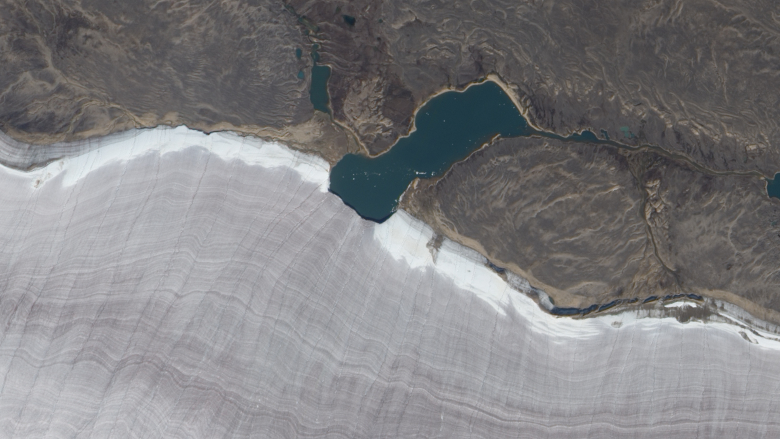
From nearly 700 kilometers above Earth, a NASA satellite captured something quietly extraordinary on September 4, 2010: a tiny lake bisecting the snow-white rim of one of Canada’s most ancient glaciers. The image is stark, almost surreal — a dark sliver of water cutting cleanly through a pale, striated mass of ice that has existed for thousands of years.
The location is Barnes Ice Cap on Baffin Island, Canada, and the lake in question is the diminutive Gee Lake. Together, they form one of the more visually arresting pairings in Arctic geography — a fleeting body of meltwater pressed against ice that has outlasted entire civilizations.
The photo, taken by NASA’s Earth Observing-1 (EO-1) satellite, is a single frozen moment in a much longer, slower story about ice, time, and a landscape that most people will never see in person.
What You’re Actually Looking at in This Image
The Barnes Ice Cap sits at approximately 69.85°N, 72.30°W on Baffin Island in Canada’s Nunavut territory. It is widely recognized as one of Canada’s oldest ice masses — a remnant of the Laurentide Ice Sheet that once blanketed much of North America during the last Ice Age.
What makes the satellite image so visually compelling is the contrast. The ice cap’s surface appears in distinctive striped gray tones — a visual texture created by layers of compressed ice and debris accumulated over millennia. Against that ancient, weathered gray, the snowy rim of the glacier appears almost blindingly white. And cutting right through that white boundary is Gee Lake, small and dark, like a brushstroke drawn across the edge of the ice.
It’s the kind of image that looks almost edited, but it isn’t. This is simply what the Canadian Arctic looks like from space.
The Barnes Ice Cap: Canada’s Oldest Surviving Ice Mass
The Barnes Ice Cap is no ordinary glacier. Scientists consider it one of the last surviving remnants of the Laurentide Ice Sheet — the colossal glacial system that once stretched across most of Canada and the northern United States. While that ice sheet disappeared roughly 10,000 years ago as the climate warmed, the Barnes Ice Cap held on.
Its surface texture, visible even from orbit, tells that story. The striped, gray appearance of the ice in the NASA photograph reflects the cap’s age and composition — layers built up not over decades but over thousands of years, compressed under their own weight, embedded with rock and sediment picked up as the glacier moved.
Baffin Island itself is a vast, largely uninhabited landscape in the Canadian Arctic Archipelago. It is the largest island in Canada and the fifth largest in the world. The conditions there — long, brutal winters and short, cool summers — are part of why a fragment of Ice Age glaciation has survived this long in this particular place.
Key Facts About the Image and Location
| Detail | Information |
|---|---|
| Location | Barnes Ice Cap, Baffin Island, Canada |
| Coordinates | 69.8543969°N, 72.30088281°W |
| Satellite | NASA Earth Observing-1 (EO-1) |
| Date Captured | September 4, 2010 |
| Subject | Gee Lake intersecting the snowy rim of the Barnes Ice Cap |
| Ice Cap Type | Ancient glacial remnant; one of Canada’s oldest ice masses |
- The photo was captured in early September, at the tail end of the Arctic summer melt season.
- The striped gray appearance of the ice cap is a visual signature of its ancient, layered composition.
- Gee Lake sits at the boundary where the glacier’s snowy edge meets the surrounding terrain.
- NASA’s EO-1 satellite was designed specifically for advanced land imaging from low Earth orbit.
Why This Corner of the Arctic Matters
Images like this one do more than satisfy curiosity about remote places. They serve as visual records of how Arctic landscapes are changing — or, in some cases, how stubbornly they are holding on.
The Barnes Ice Cap has been the subject of scientific attention precisely because of its age and its precarious position in a warming world. As one of the last direct links to the Laurentide Ice Sheet, it represents a kind of frozen archive — a record of climate conditions stretching back thousands of years locked within its layered ice.
Gee Lake, the small body of water visible in the 2010 image, is itself a product of glacial processes. Lakes like this form at the margins of ice caps where meltwater collects, held in place by the topography shaped by the glacier itself. Their presence — and their size — can shift from year to year depending on seasonal melt and temperature.
From 700 kilometers up, what looks like a simple, beautiful photograph is actually a data point in a much larger record of how one of Earth’s oldest ice masses is faring.
What the NASA EO-1 Satellite Was Built to Do
The Earth Observing-1 satellite, which captured this image, was part of NASA’s Earth Science Technology program. Launched in November 2000, EO-1 was designed to test advanced land-imaging technologies and provide high-resolution views of Earth’s surface for scientific analysis.
Over its operational life, EO-1 captured thousands of images of remote and scientifically significant locations around the world — from volcanic eruptions to flood zones to Arctic ice fields like the one seen here. The satellite was decommissioned in 2017, but its archive of imagery continues to be used by researchers studying land surface changes over time.
The September 2010 image of Gee Lake and the Barnes Ice Cap is a small but striking example of what that mission produced: a clear-eyed view of places most of us will only ever see from space.
Frequently Asked Questions
Where exactly is the Barnes Ice Cap located?
The Barnes Ice Cap is located on Baffin Island, Canada, at approximately 69.85°N, 72.30°W in the Nunavut territory.
What is Gee Lake?
Gee Lake is a small lake that intersects the snowy rim of the Barnes Ice Cap, visible in the NASA satellite image captured on September 4, 2010.
Which satellite took the photograph?
The image was captured by NASA’s Earth Observing-1 (EO-1) satellite.
Why does the ice cap appear striped and gray in the photo?
The distinctive striped gray appearance reflects the ancient, layered composition of the ice cap, which is considered one of Canada’s oldest ice masses and a remnant of the last Ice Age.
When was the photograph taken?
The satellite image was taken on September 4, 2010, near the end of the Arctic summer melt season.
Is the Barnes Ice Cap still intact today?


Leave a Reply