
Something 1.85 kilometers wide slammed into what is now northeastern China roughly 46,000 to 53,000 years ago — and for tens of thousands of years after that, almost nobody knew it happened. Trees grew over it. Wetlands settled into it. Farmers worked around its edges. Local people gave it a name, “Quanshan,” meaning “circular mountain ridge,” and thought nothing more of it.
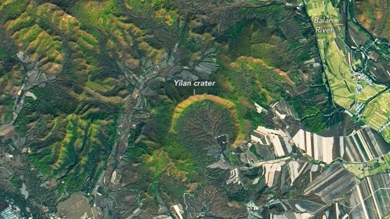
It took a satellite orbiting hundreds of miles above Earth to finally reveal the truth. NASA’s Earth Observatory has spotlighted the Yilan crater in Heilongjiang Province, China, confirming it as the largest known impact crater on Earth that formed within the last 100,000 years. That distinction alone is extraordinary. But the real story here is how something this massive stayed hidden in plain sight for so long — and what it took to finally see it.
The crater sits in the Lesser Xing’an mountain range, a heavily forested region in northeastern China where the landscape rolls quietly and gives nothing away from the ground. From space, the picture looks very different.
What NASA Actually Found Looking Down at China
NASA’s Earth Observatory used imagery from Landsat 8, a joint NASA and U.S. Geological Survey satellite, to capture the Yilan crater in a way that ground-level observation simply cannot. From above, the circular structure becomes unmistakable — a near-perfect arc of ridgeline cutting through the forest, the kind of geometry that nature rarely produces on its own but that asteroid impacts leave with striking regularity.
The crater measures 1.85 kilometers wide, or roughly 1.15 miles across. That is not the largest impact crater ever found on Earth by total size, but it earns a specific and significant record: it is the largest confirmed crater known to have formed in the past 100,000 years. That makes it geologically young, scientifically valuable, and, until relatively recently, almost completely overlooked.
The forest covering the region is part of why it stayed unknown for so long. Dense tree cover, wetlands, and farmland filled the basin and grew up along the ridges, blurring the circular shape that would otherwise stand out. From the ground, walking through it, you would have no reason to suspect you were standing inside the remnants of a violent cosmic collision.
The Numbers Behind the Yilan Crater Discovery
| Feature | Detail |
|---|---|
| Location | Heilongjiang Province, northeastern China |
| Crater width | 1.85 kilometers (approximately 1.15 miles) |
| Estimated age | 46,000 to 53,000 years old |
| Record held | Largest known crater on Earth younger than 100,000 years |
| Surrounding landscape | Lesser Xing’an mountain range — forested, with wetlands and farmland |
| Local name before discovery | “Quanshan” — meaning “circular mountain ridge” |
| Satellite used | Landsat 8 (NASA / U.S. Geological Survey) |
The age range of 46,000 to 53,000 years places the impact during a period when early modern humans were present in parts of Asia. Whether anyone witnessed the event — a fireball, a shockwave, an impact that would have leveled everything for miles — is impossible to say. But the timing puts it well within the era of human prehistory, not the deep geological past.
Why Hidden Craters Like This One Matter to Science
Impact craters are not just geological curiosities. They are records of the solar system’s violent history, preserved in rock and sediment. Every confirmed crater adds to scientists’ understanding of how often large objects strike Earth, how those strikes are distributed across time and geography, and what kind of damage they cause.
The fact that a crater of this size — nearly two kilometers wide — went unrecognized for so long raises a practical question that researchers take seriously: how many others are still out there, hiding under forests, ice sheets, ocean floors, or simply overlooked terrain?
Satellite imaging has become one of the most powerful tools for answering that question. Landsat 8 and similar instruments can detect circular anomalies in terrain that ground surveys miss entirely. The Yilan crater is a clear example of what becomes visible only when you change your perspective — literally, by going higher.
Scientists argue that younger craters like Yilan are especially valuable because they are better preserved. Older craters have been worn down by millions of years of erosion, tectonic activity, and vegetation. A crater that formed 50,000 years ago still holds much of its original structure, making it easier to study the mechanics of the impact itself.
What This Means for How We Read the Landscape
There is something quietly humbling about the Yilan story. A structure nearly two kilometers across, sitting in a populated region of China, known to local communities for generations — and yet its true origin went unrecognized until geologists and satellite imagery caught up with it.
It is a reminder that the Earth’s surface carries scars we have not yet learned to read. The circular ridge that locals called “Quanshan” was always there. The impact happened tens of thousands of years ago. The evidence was visible, in its own way, the entire time. It just required the right tools, the right angle, and the right scientific framework to understand what it was actually showing.
NASA’s continued use of Earth observation satellites for geology, ecology, and climate science produces exactly these kinds of discoveries — findings that reframe something ordinary into something that changes our understanding of the ground beneath our feet.
Frequently Asked Questions
Where is the Yilan crater located?
The Yilan crater is located in Heilongjiang Province in northeastern China, within the Lesser Xing’an mountain range.
How wide is the Yilan crater?
The crater measures 1.85 kilometers wide, which is approximately 1.15 miles across.
How old is the Yilan crater?
Scientists estimate it formed between 46,000 and 53,000 years ago, making it geologically young by crater standards.
What record does the Yilan crater hold?
It is recognized as the largest known impact crater on Earth that is younger than 100,000 years old.
How did NASA spot the crater?
NASA’s Earth Observatory used Landsat 8 satellite imagery to capture the circular structure, which is difficult to identify from ground level due to the surrounding forest, wetlands, and farmland.
Why did locals not recognize it as a crater before?
From the ground, the formation looked like a natural circular ridge and was known simply as “Quanshan,” meaning “circular mountain ridge.” The true impact origin was not apparent without aerial or satellite observation and geological analysis.


Leave a Reply