
Somewhere beneath one of the most studied monuments on Earth, researchers say they may have found something that changes everything — massive hidden chambers, vertical shafts, and spiral pathways buried so deep that no shovel has ever come close to reaching them.
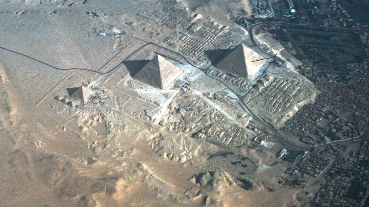
In March 2025, a team of researchers announced at a press conference in Italy that satellite radar images suggest vast underground structures exist beneath the Pyramid of Khafre, the second-largest pyramid at Giza. The claim is extraordinary. So is the skepticism surrounding it.
No drilling, no excavation, and no independent field survey has confirmed any of what the team describes. That gap between the claim and the confirmation is exactly why this story has become one of the most contested in recent archaeological memory.
What the Researchers Say They Found Beneath the Great Pyramid of Giza
The team behind the announcement includes Corrado Malanga of the University of Pisa, Filippo Biondi, described as linked to the University of Strathclyde, and a researcher named Armando Mei. Together, they say they processed satellite synthetic aperture radar — known as SAR — data and used it to map what they interpret as underground features of enormous scale.
Their description of those features is striking. According to accounts of their March 2025 presentation, the alleged structures include massive vertical shafts, spiral pathways, and large chambers. The team says these features extend more than 2,000 feet underground — with some accounts placing the deepest alleged structures at roughly 1.2 miles beneath the surface.
Among the most unusual claims is the reported presence of two cube-like formations deep within the earth. The researchers presented their findings publicly, but as of the time of reporting, no peer-reviewed publication of the data or methodology had been confirmed.
Why Specialists Are Pushing Back Hard
The scientific community’s response has been pointed. Many specialists in archaeology and remote sensing argue that the claims go well beyond what satellite radar technology can reliably demonstrate.
Synthetic aperture radar is a legitimate and widely used tool in remote sensing. It can detect surface features, slight ground deformations, and in some cases shallow subsurface variations. But claiming it can resolve detailed underground architecture at depths of over a mile is a significant leap — one that most experts in the field say is not supported by the current capabilities of the technology.
The fact that the findings were announced at a press conference rather than through a peer-reviewed scientific journal has added to the skepticism. In archaeology, extraordinary claims require extraordinary evidence, and the standard path for that evidence runs through independent verification and rigorous academic review — neither of which has happened here.
The Key Claims at a Glance
| Claim | Detail | Verification Status |
|---|---|---|
| Location of structures | Beneath the Pyramid of Khafre, Giza | Unverified — radar interpretation only |
| Depth of alleged features | Over 2,000 feet; some accounts say ~1.2 miles | Unverified — no excavation conducted |
| Described features | Vertical shafts, spiral pathways, large chambers, two cube-like formations | Unverified — based on radar data interpretation |
| Method used | Satellite synthetic aperture radar (SAR) | Legitimate technology; application disputed by specialists |
| Announcement venue | Press conference in Italy, March 2025 | Confirmed; no peer-reviewed publication confirmed |
| Independent field survey | None conducted | Confirmed absent |
The researchers named in the announcement — Malanga, Biondi, and Mei — have not, based on available reporting, provided raw data for independent analysis or submitted findings through conventional academic channels.
Why This Matters Beyond the Headlines
The Pyramid of Khafre and its neighbors at Giza are among the most excavated and studied sites in human history. The idea that something enormous could still be hiding beneath them — something missed by generations of archaeologists, engineers, and scientists — is the kind of claim that captures public imagination for obvious reasons.
But the way this story has unfolded also reflects a broader tension in modern archaeology: the growing use of non-invasive technology like ground-penetrating radar, LiDAR, and satellite imaging to probe ancient sites, and the very real risk of misinterpreting that data without physical confirmation.
Remote sensing tools have genuinely transformed archaeology in recent decades. They have helped locate buried cities in the jungles of Central America, revealed hidden features at Stonehenge, and mapped ancient road networks invisible from the ground. But every significant discovery made with these tools has eventually required on-the-ground verification before the scientific community accepted it.
- Satellite radar can detect surface and near-surface anomalies effectively
- Interpreting deep subsurface architecture from radar alone is not an established capability
- No independent team has reviewed or replicated the data
- The Pyramid of Khafre is protected — any physical investigation would require Egyptian government approval
For the public, the story is thrilling. For archaeologists, it is a reminder of why process matters as much as discovery.
What Would Need to Happen for This to Be Taken Seriously
The path from “press conference claim” to “accepted scientific finding” is long and demanding. For this particular announcement to move forward in any credible way, several things would need to occur.
First, the raw radar data would need to be released and independently analyzed by remote sensing experts with no connection to the original team. Second, the methodology would need to be submitted to peer review in a recognized scientific journal. Third, and most critically, any physical confirmation would require coordination with Egyptian authorities, who oversee access to Giza with strict controls.
None of those steps have been confirmed as underway. Until they are, the claim remains exactly that — a claim.
Frequently Asked Questions
Which pyramid is at the center of this claim?
The researchers say the alleged underground structures lie beneath the Pyramid of Khafre, the second-largest pyramid at Giza.
Who made the announcement?
The announcement was made by Corrado Malanga of the University of Pisa, Filippo Biondi, described as linked to the University of Strathclyde, and Armando Mei, at a press conference in Italy in March 2025.
How deep are the alleged hidden structures supposed to be?
The team claims the structures extend more than 2,000 feet underground, with some accounts placing the deepest features at approximately 1.2 miles beneath the surface.
Has any physical excavation confirmed these findings?
No. No drilling, excavation, or independent field survey has been conducted to verify the claims.
Why are experts skeptical?
Many specialists argue that the claims exceed what satellite synthetic aperture radar technology can reliably show, and the findings have not been submitted for peer review or independently verified.
Could this discovery be confirmed in the future?
Confirmation would require independent analysis of the raw data, peer-reviewed publication, and physical investigation approved by Egyptian authorities — none of which has been confirmed as underway.


Leave a Reply